West Highland Way (2017)
Scotland at its most beautiful and rugged
In West-Scotland is the country's oldest and most famous hiking trail: the West Highland Way. Just 152 km long, but because of the beautiful nature it’s is a treat for every hiking enthusiast. And in Scotland I'm trying something new: camping. This will be my first trek where I have not booked or planned anything. For me that is the most exciting part of this trip, because I like to be in control and to know in the morning where I will be sleeping at night. How will that turn out now?
Day 1: Milgnavie - Milarrochy bay, 32km
The day is getting off to a good start. When I arrive at the obelisk which marks the start of the West Highland Way in Milngavie, it is gray, but dry. The only water I hear is a stream which ripples across the rocks and disappears under the shopping street in a culvert. I follow the Allander Water out of Milgnavie, almost immediately into a tunnel of greenery. On the right is a road and on the other side I suspect factories, but as a hiker you hardly notice them and you feel like you are in nature right away. I reach a forest via what looks like an old railway line. Deep purple flowers cover the ground, the trees are adorned with the fresh green of spring. At Allander Park there’s the first, steep climb away from the water. The view you would expect here remains hidden in the white clouds that drape low across the hills. A little later the park turns into Mugdog Wood and that is one of the highlights of this first day. A forest like a fairytale, full of green and flowers. The brook shows itself again, although the water now floats silently through the wide bed. One cuckoo shouts in the distance, another answers. The route winds and climbs and then descends again. A small path which surprises me. Some 50,000 people walk this trail every year, Scotland's oldest long-distance path. And all this on a beautiful little winding path? But I probably strayed slightly from the route, because I end up on an asphalt road where I no longer see any way markings. A little bit back in the forest, I see a wider path parallel to the small winding path, which seems more logical for such a popular trail. And there I discover another way marker with the now familiar white thistle. Then it starts to rain. Initially a friendly splash, but it turns into the torrential rain for which Scotland is known. Underneath a tree I put on my rain pants, but I can't find the rain cover for my backpack quickly. Optimistic as I am, I have hidden it somewhere deep inside and I don't feel like unpacking the backpack completely. I walk on in a good mood. A little rain doesn't get me down and it's not that bad. Moreover, it has been a clear blue and sunny in Scotland for the past three weeks and both nature and the farmers are desperate for rain. There are some candy wrappers on a pole, completely contradicting the hiking habit of leaving no trace. Surprised I take them with me and one of them still contains Mars bar. Now, that will go down nicely. On a wide gravel path I walk past Craigallian loch and a little later past a few beautiful holiday homes surrounding Carbeth loch. The first kilometers I have not seen many hikers, but now I am overtaken by quite a few. Without exception they carry daypacks, I am the only one not having my luggage transported, it seems. I also belong to the 10% of the hikers who camp. For me it’s the first time that I have been hiking with a tent and I am curious what to expect. After a short distance I leave the forest and enter a landscape of low grass. On the horizon the first hill, Dumgoyach, appears like a sweet dessert rising from the landscape. A little further on, at Dumgoyach Bridge, the route turns onto an old railway which I follow for several kilometers. That might be boring, but because it clears up, it’s not. The hills on either side turn green instead of gray and every now and then the tinny sound of a pheasant can be heard. I pass a restaurant and sit down on a railroad structure for a snack. The railway continues, less and less recognizable as such. Several streams crawl under the slope and robins sing their sweet delight. I also recognize the rolling sound of the redshank, which I have not heard often even in the Netherlands this year. When I am finally allowed to leave the railway, that is not an improvement at first, because I am exchanging a straight line for a stretch along the busy A81. Fortunately it is only short and I can soon turn to Gartness. There the waterfall is a real attraction. On the right side of the bridge, the water gently flows across a dam and you would not suspect that the left side is so spectacular. There, the water pours across brown stones, into which it has carved out special shapes. Perfectly round holes, but there’s also a stone that the water gnaws at from below. Gartness is a hamlet of only a few houses, I hike towards Drymen via the quiet asphalt road. The trail passes the village on the right and although I am quite hungry, I do not detour for a cuppa. Fortunately, there is an 'honesty box', a cool box full of goodies, at a B&B, the payment to be deposited in the letterbox. “No euros”, it says and apparently that’s necessary. After a short distance I turn into a forest, although as a forest it doesn’t count for much. A wide gravel road between dark production forest. Every now and then a storm has wreaked havoc, but there are also bare slopes where trees have been harvested without compassion. Most of the hikers have stopped in Drymen and it becomes quiet on the route, until I meet a Scottish father and son with whom I hang out for a while. We also meet hikers who are on their way to Drymen or further. There is a young man who doesn't look like he is still having a good time and an overweight man in his thirties who breathes a sigh of with relief when I assure him it is not far. A little further down the road I find a Dextro energy bar on the path and if someone wanted to make it clear to me that I cannot make it with hardkeks alone, I get the message already. Just before I leave the forest I have to choose: high or low. The high route goes along Conic Hill. Due to lambing season, the high route is closed to dogs, but hikers are welcome. The low route goes along the road to Balmaha and that seems a bit boring to me. Of course I choose the high route and after a few hours I feel safe enough to take off my warm rain pants. Well before I stepped onto its flanks, Conic hill appears on the horizon, initially still gray, but when the sun breaks through a pleasant green. It’s the first of a series of mountains which gently descend to the light glint of Loch Lomond in the distance, which I will be introduced to in the coming days. The landscape here is rougher, with no signs of human civilization or those disfiguring power pylons that I regretted earlier today. A patchwork of shades of brown and green grass clumps, with a lonely tree which stands out against the increasingly graying sky. This time I don't just hear the cuckoo, I see them, two even. It’s that they call during their flight, otherwise I would have mistaken them for a pigeons in this bad light. I cross Burn of Mar via a bridge and start climbing. The route does not go across the top, but although 361 meters did not seem high, it is quite intimidating standing at the base of it. And then it starts to rain again. First deceptively soft, then a seemingly unstoppable deluge. Too late to put my rain pants back on and I stubbornly hike on. Still, there's plenty to enjoy, as at the rear of Conic Hill, a view of Loch Lomond unfolds that may not be as spectacular as on sunny days, but still is pleasantly mysterious. Gray finger rolls from the water into the hills, islands are surrounded by pale moisture. Surprisingly, I meet a lot of people here. A fully packed hiker who is still on her way to Drymen, but also many day trippers who take a trip from the parking lot on the outskirts of Balmaha to the top of Conic Hill. Rather them than me, if I wasn't walking the West Highland Way, I would have stayed indoors in this weather. Fortunately it gets better as I get lower and when I descend through a forest with ferns sticking out of the ground like arrows, it even gets dry. Still, I'm starting to get chilled by now and I've had it for today. However, the campsite is a bit outside of Balmaha, so I have a ways to go. There is a nice winding path through the forest to a hill where I would certainly stop for the view on another day and from there I go down again. The last part is across the stone beach of Milarrochy Bay and here I immediately forget my wet coat and sore feet. In the center of the stones is a tree, its roots protruding high above the beach, against a spectacular backdrop of water and hills. Further on there are similar trees, each time a solitary one, but none are as spectacular as the first. Possibly there used to be soil which has washed away, leaving the trees in this unlikely setting. Either way it is a special sight and I enjoy it. Especially when I spot tents on the other side of the beach. It’s been enough for today.

Day 2: Milarrochy Bay - Cailness + Ben Lomond, 30 km
As gray and damp as it was yesterday, as beautiful is the morning which greets Loch Lomond now. Across the road, the hills are flecked yellow-green where the sun hits them and I can even see blue skies. I am one of the first to set out, after a short distance hiking into a forest. The trail follows Loch Lomond to its end all day, and for a bit into tomorrow. That in no way means this part of the West Highland Way is boring, although I can imagine that people who walk shorter stages will tire of it after a few days. But the forest changes character every time, from an open deciduous forest full of purple flowers to a pine forest with a delicious scent and then again a forest full of young ferns. The path undulates up and down, surrounded by the greenery. I am almost starting to regret there is not a bare, open area from which to admire the mountains that occasionally peak so seductively through the treetops. Then there is a short stretch along the road and I have an unobstructed view of the water, the islands and the hills on the other side. The hills on this side of the lake remain a surprise. At a boathouse where a device is humming noisily, the route turns away from the water, circling the Ross Wood headland. Every now and then I can see a mountain from the trail and slowly the plan to climb Ben Lomond bubbles up, which was actually not on my schedule. At 914 meters it is not as high as Ben Nevis, but on fine days the mountain should offer a spectacular view of Loch Lomond. And it is a beautiful day, so why not? I promise myself the top, provided I can park my heavy backpack somewhere. The path returns to the road, which turns to Rowardennan, a village too small to be called a hamlet, I think. A hotel, a bar and a ferry to the much larger Tarbet across the lake, that’s about it. In the bar I first enjoy a heavy cake and the view across the water and the top of Ben Lomond. Every now and then the top of the mountain is shrouded in gray, but they are always short showers. I leave my backpack in the shed of the hotel where the transported luggage arrives and continue with only a daypack. I suddenly feel wonderfully light. I hike to the parking lot further on where the public road ends and the trail to Ben Lohmond begins. It immediately becomes clear that the trail is extremely popular. I am certainly not alone. Dozens of hikers go up, some with their dogs. Others are coming down again, which is a lot faster. The path is neither hard nor difficult, only it persists in ascent, six kilometers long. There are stone steps, gravel, rocks. Slowly the trees get smaller until I have passed the tree line and only grass and moss remain. The higher I get, the more spectacular the view of Loch Lomond and all its islands. It is so clear that I can see the distant tip of the lake beyond Balmaha. But the hinterland is also impressive. A beautiful succession of brown tones, a meandering brook below, a distant loch. I am so happy I made this trip, a highlight in an otherwise not very special day. On the way to the top I worry if I will make it to Inversnaid this afternoon. Then I scold myself. I am hiking a great hike here, why would I think about a schedule? I have not booked anything, am not expected anywhere. Live in the here and now, I tell myself and return my attention to my feet and the path to Ben Lomond's crown. The top is marked by an inconspicuous concrete post and even that is unnecessary. The countless people sitting there, resting for the descent, says enough. A mountain biker, who has lugged his bike six km up, receives well-deserved applause. I look in all directions and it is beautiful everywhere. The rocks, the water, the endless horizon full of hills, the cliff of yellow moss across which light gray tufts of cloud quietly float. However, the wind is too strong to stand still and after fifteen minutes I point my feet back to the same path. There is also another route down, but it ends somewhere outside of Rowardennan and I don't know exactly how far. I don't want to have to walk back to pick up my backpack and choose the usual road. At this altitude and with this wind it is cold and I am starting to feel my fingers. And blimey, I promptly find a pair of gloves in my size on the trail. Wonderfully warm. Going down is faster than up and the path seems easier than I remember from the way there. It becomes quieter on the path, I only meet a few people who are sweating and taking pictures. Once back at the bar, I first order the smoked salmon sandwich I promised myself. Then I pick up my backpack and the West Highland Way again. I'm happy. The trail continues to follow the bank through the most beautiful forests. There are streams, bridges, platforms across moist soil. Moss in all kinds of colors and I suspect there must be sundew, although I don't feel like looking for it. Only the busy A2 to Inverness across Loch Lomond casts a blemish on the idyll. The evening rush hour traffic is very audible, with the occasional motorcycle or truck to emphasize civilization is not that far away. My jaunt to Ben Lomond has taken about five hours and I am well behind my schedule for today. Still, I am not tired and keep going. It is wonderful to have the trail to myself, alone with the birds. After a few steps I meet three Scots, busy with blister plasters. They still want to go to Inverarnan, but realize they are not going to make it. Inversnaid, my intended end point, is still six kilometers, they suspect when they consult their GPS. That seems doable, until my body gives the unmistakable signal I am asking too much of it. I have now left the National Park and wild camping is allowed. After having to dive into the bushes for the second time in a short while for some brown blazing, I decide that it’s been enough. In the first suitable spot, a flat patch of land between the trees overlooking Loch Lomond, I pitch my tent and crawl into my sleeping bag, while the birds sing me to sleep.

Day 3: Cailness - Inverarnan, 13 kilometer
I am lucky that I can still fold up my tent while it’s dry, but shortly after I go out again, it starts to rain and it doesn't stop for the rest of the day. Fortunately I am well prepared this time and I start the day with my rain pants on and the rain cover tightly around my backpack. Still there is still plenty to enjoy and I don't know if the landscape would have looked much nicer with the sun than it is now. The path weaves through pleasant green forest and the purple flowers are everywhere. There are countless streams that I cross via stepping stones . Every now and then I catch a glimpse of Loch Lomond through the trees, where the mountains rise like gray shadows. A strange cairn of stones and branches along the path turns out to be a monument to Bill Lobban. The 41-year-old teacher gave his life in November 1975 to save two other teachers and a 17-year-old student when they lost their balance while fording Cailness Burn and were dragged into Loch Lomond by the water. I pass rocks, made up of layers, as if millennia of history were set in stone, which probably is the case. There are no other hikers yet and the few tents that line the path between the trees are shrouded in silence. Just like the road on the other side, where the morning rush hour seems to have passed. Or maybe the wind is favorable today. In any case, I barely hear it and I am very happy with that. Only the familiar thumping of a train can be followed far across the water. Inversnaid is further than I thought and as time goes by and I brave one climb after another, I know I did well yesterday to stop where I did. I really couldn't have done this last night. Now things are going fine, however, and after about an hour and a half, a deep rumble heralds Inversnaid's waterfall, which is larger than any of the falls to date. It is an impressive sight and the rain certainly contributes to that. The water plunges down two steps and I walk past the hotel to take a picture not showing any overhanging branches. After some scrambling across stones that are not quite officially accessible, I take the picture I wanted. For a moment I’m not sure whether I will turn to a campsite here, about 1 kilometer from the trail, but I’ve barely started and want to continue. The rain can’t last all day, can it? I don't see any markings and thoughtlessly follow the road up past breakfast hotel guests. Only when the road turns inland do I sense I am wrong. For the first time this holiday I consult the route in my guidebook and then retrace my steps. And indeed, along the water is a worn marking, hidden behind the two coaches in the parking lot. What follows is a path which starts slowly, but soon becomes more challenging. There are steps made of stone, rocks and roots. It is scrambling and puzzling, fun but tough. All the more surprising that two mountain bikers follow me, who are cycling the West Highland Way. Only there is not much to cycle here and they regularly carry their mountain bikes on their shoulder across difficult points. When they do jump on their saddles again, their continuous braking sounds like nails on a chalkboard. Fortunately, they quickly disappear around a bend and I don't hear them anymore. I steadily clamber on, cheerfully and optimistically looking at the lightening sky in the distance. Sometimes the rain subsides to a drizzle, making it seem almost dry. The forest also keeps throwing new wonders my way. Trees grow right on the rocks, both so thick with moss that I can only guess where one ends and the other begins. After a particularly nasty part I descend to a sign announcing Rob Roy's cave, but there’s no real cave. Then there is an open area, where I have a great view of the lake and the mountains. The stretch directly in front of my feet is even more beautiful if possible: purple flowers and the red of dead ferns alternate, with a few white flowering trees in between. It's a picture. In the lake a few islands are getting closer and I know that things are moving forward. Suddenly I see the mountain bikers again, their bikes on their shoulders as an ominous sign of things to come. It's a steep staircase to a bridge, which spans a drizzly stream. You cannot call this a waterfall, the water flows past a slimy rock and then collects in a narrow river bed to flow to Loch Lomond. I walk ahead and quickly leave the two mountain bikers behind me. Although Loch Lomond continues for a while, the West Highland Way curves away from the water at a sandy beach to a wood, where I follow a particularly attractive stream up. The mountain bikers, who can now really cycle, catch up with me and disappear around a bend. When I follow them, it turns out that the route has been feinting, because on the other side of a hill the lake stretches out in front of me again. Neat the shore is what looks like a dilapidated farm, but it turns out to be Doune Byre Bothy, a hut where hikers can spend the night or, like today, shelter from the rain. As it continues to pour outside, I join the mountain bikers and two hikers who enter shortly after me. I'm starting to realize I don't want to make it to Tyndrum today. I pull my trump card. After the West Highland Way I planned two zeros and I sacrifice one of them so I can take the first campsite after Inversnaid. Because I do want to spend the night in Tyndrum, I will walk that stage tomorrow. The campsite there has a washing machine and a drying room and the first day the clothes in my backpack have gotten quite damp. That means a very short day today, but the weather demands it. Although I am normally super organized and have planned and booked everything well in advance, I now enjoy the freedom to just quit when I don't feel like hiking anymore. It takes some getting used to, but it also feels great. Hopefully we won't get another day like this, because I want to climb Ben Nevis on my second zero. Resting just doesn't suit me. As I continue, the route curls away from the water around some hefty hills. I meet two walkers who turn out to be Dutch. Although they do regular smaller walks, this is their first experience of a trek. They sleep in hotels and b & b's and have to move on, despite their blisters and the persistent downpour. I enjoy the prospect of not having to go that far and keep looking around me. On the other side of the valley, a powerful waterfall cascades down the mountain side. I imagine I can hear it here. Then, after another big brook, long-awaited Inverarnan finally appears, although I get no further than the bar of Beinglas, a backpackers accommodation with small, oval huts for hikers and a green field for tents. The village itself is on the other side of the river and I really don’t care. The bar is full of hikers who have sought refuge from the rain here. A British trio want to continue to Tyndrum and are shocked when I tell them that it is still 20 kilometers. They themselves thought only fourteen. When I consult the guidebook while enjoying a tuna sandwich, I see that there are no campsites signposted until Auchtertyre, just before Tyndrum. Well, I’ll just stay here then. None too shabby. And so I’m done after 13 km already and get the short day I planned for yesterday. I just don't know how well I'll sleep with Ben Glas Burn's thunder in my ears. D
ay 4: Inverarnan - Tyndrum, 19 km
When I wake up in the morning, the fog hangs low across the hills. I pull the hood of my mummy bag over my eyes and lie back down for a while. On the second attempt the view has improved. Although I am not the first to set out, it is still fairly early. And I am so glad that I did not hike this stage yesterday. With the campsite I also leave the forest behind and with it any shelter from the elements. Now it is fairly sunny and I could make good progress on this wide gravel road if it weren't for the fact that the countless falls of Falloch River keep distracting me. Sometimes the road runs right past it, sometimes slightly above it. I keep descending carefully to see if the thunderous violence looks as spectacular as it sounds and where three streams converge that is indeed the case. The rocks are no match for the water, carved into spectacular shapes. The volume and power of the water are impressive. There is a beautiful view of the hills, countless shades of green. Beautiful, if you forget the power pylons. The road I can forgive them for and the railway does not interfere too much with the landscape. But those pylons clash with the landscape and impress upon me that humans dominate it. Luckily I get talking to an Englishman who is hiking the West Highland Way for the third time already and that distracts me nicely. We go through a low sheep creep under the railway line and a little later through a slightly higher tunnel to the other side of the A82.
The path I'm on is an old military road, once built by the English to make it easier to contain the rebellious Scots. As the road slowly turns to Crianlarich, I see a number of hikers standing by an information board that appears to be the halfway-point of the West Highland Way. It’s not very interesting and I soon enter the forest, where the trail winds and rises. It is production forest, but luckily the trees here have been left alone and a lovely pine scent surrounds me. At a babbling brook I do something unusual, I settle down on an elevation of grass and moss and enjoy the nature around me uncomplicatedly. The sound of running water dispels all thoughts. I nibble away some hardkeks and fill my camelback with fresh brook water. Delicious. Behind me hikers pass by on the trail, but I don't feel like getting up and it takes a while before I continue. I follow the stream to a graceful railway bridge and the road just behind it. One side of the road is being worked on and a traffic warden who directs cars around the work is also useful for hikers. I cross the river and find myself on a road to a distant farm. Along the road there are information signs with the names of the surrounding hills, but these are not visible because of the clouds. Under a group of trees lies the ruin of St. Fillan's church and a little later I pass a hill full of tombstones. It starts to drip again and a little later it starts to rain. Just then I pass a campsite with a small shop and a covered picnic table. Great timing. With half a liter of milk, a biscuit and a few weeks old Sunday Times I wait for it to get dry again. I am soon joined by a married couple, while other hikers walk on bundled up from head to toe. After an hour it clears up and I take a chance. While the couple turns to their overnight address, I follow the river upstream. Just before Tyndrum there’s a small heather area with a water hole to which a legend is attached. After he was defeated at Dalrigh, Robert the Bruce and his army are said to have thrown their weapons into this lake and they are still there. An information sign tells the legend and immediately invalidates it. On a map from 1867, Dalrigh and the associated lake are further south. Why the legend moved to this lake is unfortunately no longer traceable. Perhaps hoping to attract tourists, like at Loch Ness? A little further on, the path ends in an ugly and desolate spot, reminiscent of a disused parking lot. History here too, but less beautiful. Here was an old lead processing factory and nothing grows on the poisoned soil. I quickly go through the swing gate to leave this lifeless place behind and hike into the forest at the edge of Tyndrum. I follow a small river which meanders behind the campsites. I skip the first campsite, the second is my goal. And just when I arrive, the sun breaks through. I could go on for hours in this weather. Still I don't walk any further. After four days I finally want to have dry shoes again.
Day 5: Tyndrum - Kingshouse Hotel, 30 km
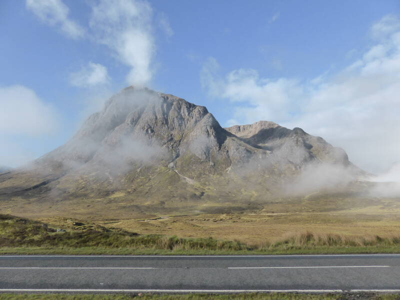
The sun is shining. It's unexpected, but true. Good weather is particularly important on this stage, as it largely runs along the edge of Rannoch Moor, a bare heath land without any shelter. Enthusiastically I pack my things and hit the road. It is still quite cold and somewhat reluctantly I take off some layers already, because I will soon feel warm while walking. Then I leave the campsite and immediately get back on the West Highland Way. Only for me to stop immediately again, because the brook that meanders through a shallow stone bed is beautiful. A red tent is standing on a hill next to the rippling water and for a moment I am jealous, what a beautiful place to wild camp. I cross the busy A82 that runs right through the village and pass the last shop before Kinlochleven. The trail runs between the railway and the A82, along a brook which flows into a deep green gorge, but I only have eyes for the mountains rising up to the river’s right. The first is pleated like an old lady's skin. The second proudly juts out like the bow of a ship cutting the sea and I can't get the word ‘Titanic’ out of my mind. I am hiking on an old military road again, wide and easy. No wonder this stage can be nice and long. To my surprise I see a hiker walking along the road towards Tyndrum. How can you prefer asphalt to the quiet of the military road? I don’t understand it at all. The road twists and turns to the foot of the mountains and a brook skips along to my left, brightened by yellow gorse. It is such a joyous view it spontaneously makes me happy. Through a small tunnel I dive under the railway, which makes a wide arc to cross the river a little further on. Just then a train goes by and I take a picture for my father, who is mad about trains, although the blue wagons are hardly noticeable in the impressive landscape. I follow the trail back to Bridge of Orchy, where hikers are warned well in advance there are no public toilets at the railway station. Apparently they are tired of hikers in dire need asking for it in. I descend steeply to the village, a dozen houses and a hotel. When I cross the road, I see barriers which can be closed if the road is impassable by snow. The main road to Inverness? Closed? I didn’t think such a thing was possible. How rarely do we still see enough snow in the Netherlands to be bothered by it, really. At the hotel I take a short break, because even if the need is not very urgent, a pit stop is welcome. After fifteen minutes I put on my backpack and continue on my way. But again I don't get very far. The sturdy stone bridge from 1750 is beautiful in itself, but not as gorgeous as the great view it offers. A shallow, wide river tumbles across the stones on its way to the mountains on the horizon. An almost endless distance. My camera purrs satisfied and I hike on with renewed energy and joy in my steps. Especially when I immediately enter a wooded area, where I slowly climb up until I am finally surrounded by bare hills with here and there a bunch of trees and a loch. Away from civilization, a landscape as it has existed here for thousands of years. Unchanged and natural. Here is my heart. Although I enjoy the forest and flowers, nothing makes me happier than the endless diversity of the mountains. The extensive color palette, the naked roughness. The view changes around every bend, with every cloud and sunbeam a new rainbow of colors unfolds. There are even mountains with snow. Initially, the trail takes me on an old military road, which is fine. A loch appears and I descend to it. That brings me to Inveroran Hotel, the only building for kilometers around. My original plan was to stop here today. But if I've learned one thing over the past few days, it’s that you should take advantage of dry weather as long as it lasts. And after two short days I have plenty of energy. My feet are itching to keep going and I happily give in. I follow the asphalt road past the hotel to a small river, where a tent in the bend of a river has the most enviable view I have encountered so far. There's a reason wild camping attracts me and this view is all that and more. Another river presents itself, just as postcard-worthy, like about every view on all sides. At a lonely B&B the route dives into a patch of forest and we get a drovers road, a road on which highlanders brought their cattle to the market. Sharp, uneven stones and that’s a bit challenging for a moment. Finally gravel follows, which feels better underfoot. When I sit down to rest, I see a doe walking in a field below. If she hadn't moved, I wouldn't have noticed. I hike along the edge of a forest while several hikers follow me or sit in the grass for a lunch break. At the end of the forest there’s another open plain. On the left a few low mountains, on the right a wide view with the road in the distance across which tiny cars and trucks move silently. It's not boring. Each meter has its own appeal. A capriciously shaped pool. Sunlight playing with two mountains. A stream which rushes across the rocks. A few plantations, square stamps of forest, in the middle of the void, unnaturally austere and disturbing. I pass a small lake, Lochan Mhic Pheadair Ruaidhe, and take a short break a little further at Bà Bridge. Here, the small river Bà winds its way down to join another river, which flows into a large loch in the distance. It feels so peaceful and I feel like I am alone in the world. A feeling that is rudely torn as a gray military cargo plane flies very low through the valley. It is located well below the hilltops, at most a few hundred meters high. Later I hear that the English are holding low flying exercises here and I will see the plane pass by a few more times in the coming days. How special. Slowly the route starts to climb out of the valley and I look forward to new surprises the landscape will reveal. First, there's a chairlift from the Glencoe Mountain Resort ski center that crawls up a hill. Fortunately, no clearing was done to make a ski slope. At least not on this side of the mountains. The A82 is also coming on again, although I don't hear the traffic yet. But what mainly attracts my attention is nature. Impressive is Buachaille Etive Mór, Etive's great shepherd. A triangular mountain standing at the edge of two valleys, Glen Etive and Glencoe. Although the mountain is huge and the weather clear, the mountain appears to be producing its own mist as it remains vague and hazy. And indeed, a thick layer of cloud seeps out of left valley to the left, while the right-hand valley is perfectly clear. I cross a river and the road and hike on a parallel road to Kingshouse Hotel, which is under construction. A roller is in the process of leveling soil and makes a loud noise when it reverses. To my utter surprise, the does in the front yard of the hotel don't care. For a moment I suspect that it’s a deer park, but no, I don't see a fence anywhere. The animals lie relaxed in the grass, waiting to be fed with kitchen leftovers. It is only 4 pm and although I stop at the bar for a moment, I consider hiking a little while longer. Just then it starts to rain and I join the countless campers who have set up their tents along the river. I spot a small island with only one tent on it. Much better. The river is shallow and I find my way across the stones to this oasis of peace in the middle of the wild campers’ village.

Day 6: Kings House Hotel - Glen Nevis Campsite, 34 kilometers
When I've shaken the ice off my tent and stuffed my mat, sleeping bag and all the other loose stuff into my backpack, I'm gone. It's only half past six, but as usual I wake up early and the fresh morning air is too tempting to lie down. An hour ago everything was sea blue and the moon looked down on the many mountains. Now they are shrouded in a thick layer of fog, but the sun is above the horizon and I bet it will be bright when I reach the top of the Devil's Staircase. Moreover, the fog gives the landscape something mysterious and expectant, which would be missing if you could distinguish every detail. Now there is always the sense of surprise, beauty can lie behind every patch of fog and veil, and the interplay of what you can see and what you hope for has its own appeal. With full gear I find my way from the island through the shallow stream to the bank, where I pass numerous tents with hikers still sleeping. Once on the paved road, I hike along the heather-covered hills. Almost immediately I see a number of does that look up at the scraping of my trekking poles and then continue to graze quietly. Moments later I hear the rolling sound of a grouse and a bird flies to a small hill further on. Unfortunately, he is not getting closer to defend his territory, as one did two years ago on the Coast to Coast. The road curves towards the A82, where only a few cars and trucks are driving, and then turns away again. Although it is getting lighter behind me, a wall of mist remains in the valley of Glencoe. However, I do not feel that I am missing much and I am going at a brisk pace on the old military road. Then the road descends again until I hike right next to the highway. This could be annoying, but I only have an eye for the mountains, which show their impressive peaks every now and then. Where the highway disappears into the fog with a wide bend, the sun illumintes a white house, while the river meanders attractively through a stone bed. It's beautiful. Then I turn my back on the house and the mountains and start the climb with the peculiar name Devil's Staircase. The climb is neither very difficult nor very hard. Every now and then a black grouse makes itself heard and one keeps a close eye on me from behind a bush. As I get higher, the zigs and zags follow each other faster, but it is only a 259 meter climb and soon I am at the top. And then it turns out that it pays to be here first, because just over the top three does look at me in surprise. One is to the left of the cairn which marks the top and two together a little further on the right of the path that branches down again. For a moment there is a stalemate and none of us move. Then the lead doe gives a kind of short bark, something I've never heard a red deer do, and the loner joins the other two and retreats calmly across a distant hill. Only when they are a long way from me do I pay attention to the breathtaking panorama at my feet. It is unexpectedly clear, a series of sharp peaks and far in the distance a blunt peak which might be Ben Nevis. It is incredibly beautiful and I sit for fifteen minutes simply enjoying the view. When I get off the path for a moment, I discover a tent peg and am jealous again. What a great place to camp! What a view to wake up to in the morning. If it hadn't rained so hard yesterday, I might have camped here too. Still, I have no regrets and I lift my backpack to descend slowly. The view remains fantastic and I keep taking pictures, especially when a loch appears to the right to complete the picture. When I look back, I see a whole group of figures at the top. Hikers, I suspect, although I cannot imagine that so many have left Kingshouse Hotel at the same time. And my doubts turn out to be justified, because a little later I get off the path to let a whole group of mountain bikers pass me by, who plunge down the mountain at breakneck speed. Around a hill I get the first view of the valley and the white houses of Kinlochleven. The path ends at the maintenance road to a sluice, from where six thick, ugly pipes bend down together, to turn a turbine in the valley and supply the region with energy. The fact that I can see Kinlochleven does not mean that the village is also close by. I follow the road down through a birch forest and on a bridge I pause to admire the shapes of the rocks and the power of the water. On then, through a small park along the river Leven, in which all that water from the pipes is discharged with enormous force. At the bridge I leave the trail to enter the village. It has started to drizzle and the village also has the last shop before Fort William. High time for a break in the welcoming pub. A few other walkers and cyclists trickle in, sheltering from the rain that is now steadily falling. Fortunately it doesn't last long and after I have done some shopping, I pick up the trail again. After a bit along the road, the West Highland Way rises through a forest with some sparkling streams. Slowly the trees are getting scarcer and both the view of Loch Leven and the village surrounded by mountains are spectacular. Once at the top, the route turns left across a wide gravel path, while another storm is approaching in the distance. For a moment it seems to be a short shower, but if the rain continues, I take appropriate measures: rain pants, rain cover around the backpack and two mini-Oreos for the effort. And just when I have my entire outfit in order, it gets dry again… Ten minutes and two mini-oreos later I continue in a T-shirt. I share the valley with a flock of sheep and an electricity line, but the brown, wooden masts hardly stand out in the landscape and do not bother me. Numerous streams bubble and murmur along and across the path. I don't have to climb or descend much and when the sun comes out, I do something that is a rarity for me: just relax in the grass. Soon a gray curtain sliding through the valley heralds another storm and this time I am well prepared. Bundled up, I continue. It remains light rain, which is only wet due to the lack of wind and not cold or bothersome. It's nothing compared to the driving rain of yesterday afternoon. There’s no evidence the valley was ever inhabited until I come to the ruins of a small house, Tigh-na-sleubhaich, meaning ‘house next to the gorged hill’. It's quite small and I can't imagine a whole family lived here. Only thestockyards next to it seem to be in use still. A little further a second ruin, even less recognizable as a house than the first. A hiker has stretched a tarp across the remains of the door frame to sit dry. As I descend at the end of the valley, I wonder which mountain I will get to climb to get out. But both the road and the valley curves northwards, though I just call it ‘right’ and follow the road on its path down to a small plantation. According to the map and my guidebook, I should now be walking through a wooded area, but the trees that grew here were harvested a long time ago. What remained are untidy rows of brown tree trunks, like a pincushion against the mountain wall. Not very attractive. Meanwhile the afternoon is nearing its end and I am starting to look for a suitable place to wild camp. But a spot near a brook under the pines looks gloomy and dark and there’s no flat piece of ground to be seen. Moreover, the sun has broken through and the afternoon turns into a beautiful evening. I give myself another hour and a half to find a camping spot and set my alarm in case I forget the time. When I end up in a forest through a swing gate, I see that it has suffered from a storm. The trees have been felled and are crisscrossing each other. Under pressure, the wood makes a plaintive sound. No wonder forest work is being announced here. But the signs I saw along the way don't mean this jumble of trees. When I get out of the forest, there is a complete clearing at my feet. No, I will not pitch my tent here. Meanwhile, Ben Nevis has unmistakably appeared on the horizon, shrouded in shadow by its own clouds and therefore depressing looking, while his slightly lower sunlit neighbor is much more cheerful. Eventually my alarm goes off and I have not yet found a place that I like. I decide to walk to Glen Nevis Campsite, on the outskirts of Fort William. If I can't find a soft patch of grass with my own private stream, then I at least want a warm shower. And if I want to hike from 6:30 am to 8:00 pm, I will. Who will stop me? My body is not giving any alarm signs that it’s too much and rain is forecast for tomorrow. So I keep on hiking across bare hills and along roaring brooks. Ahead of me I spot a hiker who’s stumbling like an inexperienced newbie. He looks tough, with tattoos and piercings, but dressed too warmly and packed way too heavily. After a short encouragement, I leave him. Still unexpectedly, a sign post points to Fort Dùn Deardail, an old fort from the iron age. Curious I follow the path up a hill, but I have no energy anymore for a second hill and the vague shapes in the grass I can see do not convince me it’s worth it. I do have a great view of Ben Nevis and its neighbor, though. After a few pictures I return to the road, where two Germans and a French couple are just passing by. The boy is wearing a kilt and a Loch Ness tourist shirt, somewhat overly Scottish. We follow a wide gravel road and in a bend we can already see Fort William. Yet it still takes a while before we get close. The road descends very gradually and then I have to choose: Fort William is straight ahead, the campsite is to the right. I realize that even I have my limits and choose the campsite. It can’t come soon enough, because I'm really drained now and when the sun disappears over the mountains, it immediately cools down considerably.
Day 7: Ben Nevis + Glen Nevis Campsite - Fort William, 17 + 5 km
Amazed, I listen to the silence in the morning. It's not raining! A quick peek from under the canvas confirms: it will be a beautiful day. An hour later, at 6.30 am, I set out and I am certainly not the first. A group of men leaves just in ahead of me, wrapped up against the cold of morning. I have not forgotten my gloves this time either and for now I am very happy with them. Where the men turn right onto the bridge opposite the youth hostel to cross the river, I choose the bridge at the Glen Nevis Information Center on the left. It is a bit further in the wrong direction, but the way up is a bit kinder to my muscles. I cross the river and it is immediately clear that the path is being worked on. Straight through a meadow I am sent up to the Ben Nevis Inn. There the path I will follow to the top starts, initially a wide gravel road with a stone here and there, then a puzzle of larger rocks. Along the path are sturdy cubic bags which have been delivered by helicopter. I expect gravel for the upkeep of the trail, but there are huge boulders in it. And all this time I thought that use was made of rocks from the surrounding mountains themselves. What a horrible job to put those rocks in place. I continue with renewed respect for the volunteers who maintain the trail. As I get higher, a breathtaking panorama unfolds before me. Not even Ben Nevis attracts the most attention, although it dominates the horizon with its mass. The valley next to it evokes a feeling of homesickness. With my eyes I follow the route I took yesterday. I see the dark clearing, the hill where the fort should be, a loch that I think for a moment must be Loch Leven, but of course that’s impossible. Even when I look back, the view is very beautiful. Fort William is located on Loch Linnhe, a water I cannot see the end of. What a lucky bastard I am to be able to go up with such fine weather. I continue to climb past half-grown birches. First a grove, then a downward green line announces a stream. I zigzag higher up the flanks of a mountain on my way to the second. Every now and then I chase a sheep away which searches for grass along the pass. Then the path turns a corner and it ceases to be nice add polite. There are large, uneven stones which form a sloppy staircase and I carefully puzzle my way up. I am now Ben Nevis’ shadow, which is nice and cool. A stream comes down from the mountain and I wonder whether we will cross it with a ford or with a bridge. A hiker almost runs down, but pauses long enough to say that he and a large group are participating in the challenge of climbing the three highest peaks in Great Britain within 24 hours. Snowdonia and Scafell Pike he’s already done, this is the last. He must be down by 9 a.m. I quickly send him on his way, even though he still has plenty of time, and go further up myself. Before I get on Ben Nevis, I first have to go around a gorge separating the two mountains. A new trail has been constructed here and a sign urges hikers to take it so the old trail can recover from the erosion which has been caused by thousands of feet. The new path is wide and easy and when I reach the ridge it is also fairly flat. Nice to rest like that and with only a daypack I feel wonderfully free. A small lake appears and behind it a new valley full of green hills. But I turn my back on this new view and take my first steps on the flanks of Ben Nevis. It is not a difficult path, but it is merciless. It is constantly going up and I find a comfortable rhythm. On the way I pick up plastic and other waste and only when my jacket pocket starts to get quite full, I realize that it is not smart to have my wallet in the same pocket. On a green part of the slope I see some snow grouse flying up, but unfortunately they stay at a considerable distance. The top is nowhere in sight and I struggle on. Every now and then I take a moment to catch my breath and look around. Loch Linnhe turns out to be much bigger than I thought and curls in an elegant bend to the left before Fort William. I take pictures, even though the view from the top may be more beautiful. I'm not there yet and for now the top is shrouded in dense fog. Very quietly a cloud floats by at eye level. The green gives way to the many shades of gray of rock. Cairns appear along the path to lead the way. The world turns as gray as the rocks. And then there is that snow slope. Not just a snow field that you can easily cross with or without trekking poles. A slope like an exciting slide. In the middle two smooth patches, where people let themselves slide down on their bottoms. Next to it, many feet in the mushy snow have carved a kind of staircase and I am making good use of it. Three Dutch youngsters speed walk up without trekking poles and get there before I do. On the other side of the snow field the path continues, while I ignore the cairns slightly to the right. Two snowfields later I see three cairns next to each other. The Dutch boys think they are on top and take pictures of each other with a Feyenoord flag. But this cannot be the top, because the ruin of an old observatory should be there. Moreover, the ground to our left rises even further. We plow through the snow until a little further we first see a peace monument and then a simple concrete pole on a wide plinth which announces the top for real. There is also a ruin and a shelter. And that is the extent of our view. The world is white. Mindful of the warning signs, I don't investigate too much. There are deep precipices whose edge is not always clear and there is not solid rock under every snow field. It is also icy cold. I don’t stay long. When I'm at the bottom of the steep snow slope, the sun breaks through. Fifteen minutes lower it is completely clear. It looks like this will be one of fifty days of the year when Ben Nevis is not shrouded in clouds. For a moment I consider going back up, but I don't. After all, I also want to finish the West Highland Way and do some shopping in Fort William. All logical, legitimate reasons, but I still regret every step down. Fortunately my adventure is not over yet. From the wide tourist road, I see a narrow trail to another summit, slightly lower than Ben Nevis. In the distance I spot a cairn. This must be the experienced hiker route, which is not even described in the official West Highland Way guide book. If it wasn't clear I wouldn't even have considered it, but now I want to see what's on the other side of that rise. I try to discover where the tourist road and the other path meet, but as I descend further, I give up and walk across the rocks from one path to the other. From a distance the trail was clearly visible, but once I get up there it’s difficult to distinguish from the rocky slope. Fortunately, it doesn't matter much, as long as I hike up in the right direction. Then I come across a small cairn no more than five or six stones in size. It is enough to show me the way and I continue climbing until I reach the great cairn I saw from the tourist path. I hike on and get very careful. I am sensible. I don't get too close to the abyss of which I can't even see the bottom. I do not hike on the snow field of which I do not know whether it is on the edge of the mountain or over it. I am not in danger. Still, it is exciting. No warning signs here to keep you away from the edge. If you are careless here, you will die. I feel the tension in my stomach, but also enjoy the beautiful view of Ben Nevis, the serrated slope which is not at all subtly menacing. A multitude of mountains in the distance. On the edge of Ben Nevis I see figures, people on the top who now have a fantastic view. I'm still not going back. Once done, I make my way across the rocks back to the tourist path, on which I now see countless people hiking. I join them and continue down. That's easier said than done. What didn't seem so difficult going up is a crime going down. My legs yearn to be able to take a normal step, but that is not possible for the time being. Only when I reach the ridge can my muscles relax for a moment. Then the puzzle starts again, worse than before. This time I do not go to the Info Center, but take the exit to the Youth Hostel which takes me down quickly and surely. By now I am in need of some unhealthy sugars and my first stop is the camping shop. After a short break I pick up the West Highland Way again, of which I only have to hike the last three miles to Fort William. I follow the forest road back up to the pine forest and follow the way markings in the right direction. It feels good to smell pine scent again. Soon the West Highland Way descends through the woods to reach the road, which it follows all the way to the end and that’s a disappointment. It's boring and the asphalt hurts my feet. Later I discover that you can also just keep following the forest road until Braveheart Car Park and from there take the Cow Hill Circuit until the turn to the town center. You might miss West Highland Way’s ‘official’ end, a large sign outside a souvenir shop, but from Cow Hill you have a fantastic view across Fort William. I follow the markings into the city, after Inverness the second largest city in Scotland. On the edge of it I meet two hikers, one of whom is particularly crippled. He unexpectedly had a funeral this week and therefore walked two stages in one day. His heels are so blistered that he hikes on his toes. I stay with him and his friend for a moment to encourage and distract him, and then we'll reach the ‘official’ end. In a large procession of walkers we then go to the real end, at the other end of a long shopping street. The image of a seated walker invites you to be photographed with it. It’s just that a few benches behind it man is eating pizza. Whoops! All in all, these are certainly not the most beautiful kilometers of an otherwise beautiful trail. I buy a few souvenirs in the shopping street and quickly return to the campsite. This time I take the Cow Hill loop, back to nature where I belong.
View my pictures of this hike here.