Tour du Mont Blanc (2019)
Three countries, one mountain and 170 km hiking joy
Mont Blanc is not a lonely mountain, rising proudly from the valley. It is an oval, snowy peak in a row of sharper, rougher peaks. Only under a clear blue sky does Mont Blanc impress as the largest giant of the Alps. Seeing the mountain and its glaciers from Le Brevent is the highlight of the Tour du Mont Blanc, a 170 kilometer hike around the mountain range through Italy, Switzerland and France.
Day 1: Col de la Forclaz - Arpette Hut, 15 km
The bus drops me off on the pass. A hotel, kiosk and otherwise only the tranquility of green pastures surrounded by mountains. The cheerful sound of cow bells immediately makes it clear that I am in Switzerland. Next to the kiosk I get on the Tour du Mont Blanc and I immediately start well with the high variant over the Fenêtre d'Arpette of 2.665 meters. The path starts with a fast brook running along it silently through its narrow gully. I am following this gentle path in good spirits. It is a beautiful day and the Trient glacier shimmers in the distance. I meet several hikers, a man from Birmingham who is on a different route and three Danes. It doesn't feel crowded, but rather nice. After a small hut the climb to the Fenêtre d'Arpette begins, the highest point of the Tour du Mont Blanc. With every 50 meters up, the glacier gets closer and shows a different sight. The milky-white river, the gray, barren rock to which the retreating fingers reach. The last few hundred meters go up steeply along and over a scree slope. Every now and then I have to scramble, but after the GR20 I can handle anything. Once at the top, I have a lunch break while looking out over the bare walls of the Val d'Arpette. After half an hour I continue, steeply down. There is gravel and you have to be careful. I lean on my new trekking poles with my full weight and carefully choose the rocks on which to land my feet. Again a scree slope, I clamber over the huge boulders and am happy when I am back on a path. The valley is slowly getting greener. In the distance I see Champex, a pretty village with wooden houses. As I get lower, the path gets easier, although it never gets as easy as on the Col. A brook hops down and where it flows across the path, I forget that the rocks are dry, but my shoe soles are not. I fall, with my legs in the air and my head in the grass. Whoops! I scramble to my feet, which is not easy with a 20-kilo backpack, and reassure the hikers after me. I walk on, feeling only some chafing on my right hip. I trek through a forest where three bivouacs invite wild camping, but I feel like a shower and walk on to Arpette, a hut full of hikers and a colorful pallet of tents on the lawn behind. Now, isn’t that more fun than on my very own in a forest?
Day 2: Arpette Hut - La Peule dairy farm, 24 km
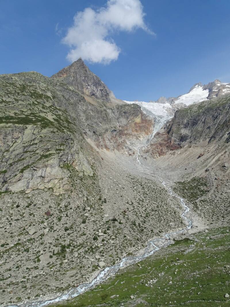
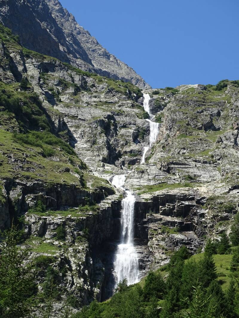
Early in the morning the valley is still in the shade and it’s cold. I do have a beautiful view of the col, where the peaks are sharply outlined against a clear blue sky. A little after eight I set off, down along a roaring river. At a lock part of the water is diverted to another stream bed. I follow the mill stream to the edge of Champex, which, apart from early hikers, is still at rest. I walk around a lake filled with clear water and descend to an educational path full of mushroom tree sculptures. The path twists and turns through the forest, countless tree roots keep my gaze down. Finally I descend to the village of Issert, where I cross a road and the Drance de Ferret, a glacier river full of gray water. After Issert a road follows along the hills to Praz de Fort, where classic Swiss wooden houses and barns are so close together that a modest car only just fits in between. Then I cross the river again and start a slow, steady climb. The shade of the pine forest offers a welcome relief, because it’s very warm again. Every now and then I have a view of the mountains, which are beautiful, but certainly not spectacular. Until I hear some rumbling and look up: a great waterfall plunges hundreds of meters down. See, now that makes my day worthwhile. When the path grazes a high cliff face, chains are in place for safety, although there is at least a meter of path between the cliff and the deep precipice. After another small climb I descend to a playground and high rope course and enter La Fouly. Here I have a great view of a row of peaks and a small glacier. After a short rest, I leave the village. The route follows the road, where there is no safe space for walkers outside the carriageway. Why don't we walk on the track along the river already, to which we will only descend later according to the guide book? Stubbornly I walk back and descend to the track. Moments later… oh… That's why. A river flows across the track to the Drance de Ferret. But this is not my first river crossing and the water is not deep. Slightly upstream there are several channels. I cross the first two with stepping stones. The third holds the most water, it is deeper and faster. I look and puzzle and jump across it. My shoes don't stay completely dry, but luckily I'm wearing gaiters. A little further I come to the bridge from the road and pick up the official route again. There is an easy gravel path to Ferret, where only the low route is marked TMB. I follow the road out of the village to a farm and descend to one last bridge. Then I start a steep climb. Now and then over a winding road, now and then a narrow path that cuts the ascending loops. Eventually I arrive at a dairy farm where the cows quietly queue up to be milked. The queue stretches out across the gravel road and after a moment of hesitation, I walk in between the cows to the farm. I pitch my tent next to two yurts with a view of the valley. And the fact that they also sell nice cold milk here is an unexpected treat.
Day 3: La Peule - Courmayeur, 25 km
Two men put a backpack full of bamboo sticks with brightly colored flags against the wall. Markers from the UTMB or one of the shorter distances of the ultra run taking place this week. From the dairy farm I zigzag up between the meadows. Every now and then I hear the whistle of an alpine marmot and a little later I see a few too, although not very close. A square top appears over the pass, covered with snow. An impressive, bleak mountain, but not yet Mont Blanc. On the pass it’s the glaciers that draw attention. Two valleys full of ice river, with rusty brown rock in between. The pass is also the border between Switzerland and Italy and the 'bonjour' with which hikers greet each other is immediately replaced by 'bongiorno'. I descend steeply zigzagging to Refugio Elena, where I have a short rest. Then I descend further, passing a steady stream of hikers and tourists. Families with small children, people in sandals, a woman carrying her tired dog and a man shuffling every step with his hand on the rocks as if at any moment he might fall into the abyss. Still amazing that he perseveres, if he is actually as afraid of heights as his posture suggests. The valley approaches, but I take a short detour to the waterfall that forces the route down. Once down I can go up again on the other side of the water. Although it is in fact the same mountainside, the trees and shrubs give the landscape a much more pleasant appearance than the earlier bare slope where grass and moss are fighting for space. The greenery feels wholesome and no matter how high I get, I never get above the tree line.Once at the top, the path flattens out. It is wide, smooth and without annoying stones and roots. It hikes wonderfully. I catch glimpses of the mountains through the trees. It's like a stage curtain behind which you catch glimpses of the props being set up. The quick, stolen looks only increase the desire for the main act. And that main act does not disappoint. Whenever I walk a little further, the perspective changes, I see the mountains as new. From Refugio Bonatti I have no fewer than three options to continue: the new route, the old and a bad weather variant. Only the new route is marked as TMB and so I follow the Val Ferret valley further to the Refugio Bertone. There I have a view of Courmayeur in the valley. A large, busy city with the entrance to the Mont Blanc tunnel, a go-kart track, flats and houses. After a day of being pampered with a super easy path, the stones on the descent take some getting used to. It's slow, but it's doable. Almost down below I run into three guys who have had enough. They ask about a camping spot, but then first have to go all the way up the hill to Refugio Bertone and further. I advise them to wild camp in the woods before dark. A little later I follow my own advice, because the site, which another hiker said was right on the route, is actually six km from Courmayeur. And that is 5.5 km more than I am willing to walk. I look for a flat spot in the forest and make myself comfortable while one thunderstorm after another rolls past above me.
Day 4: Courmayeur - Rifugio Elisabetta Soldini, 18 km
From my spot in the forest I descend to Courmayeur. It takes a while to find the church, but eventually I arrive at the bus station where the route continues towards Dolonne. The clouds are low and hide the mountains from view. I start to climb at a cable car. The mark of the UTMB is moving up and I can't imagine running this. The path zigzags and climbs and once at the top, the cabins slide into their final station. The cable car is located at the foot of a ski area, which makes a soulless impression for the winter. At a few places work is being done to prepare the area for the winter’s snow. The pulleys of a cable car are oiled by two men who hang in a container underneath, a tractor does whatever it is they do with tractors here. At the next cable car I have to search for the route. There is an arrow pointing to the right, back to Courmayeur according to my sense of direction. I give the marker the benefit of the doubt, but moments later a sign post confirms that I'm heading in exactly the wrong direction. Back it is. I follow the ski slope further up until I reach a cafe. Here I have a break that grows to an hour after it starts to rain. A lazy day today, but that was the plan. After three days of walking, I am sticking to a single leg.
When I emerge from the building again, it has cleared up. I leave the ski slope behind, there is only the path and the mountains again. New glaciers come into view, half hidden behind a thin layer of clouds. In front of me, two walkers stop at something on the path. As I get closer, I see a young alpine marmot spinning in circles around its longitudinal axis. Although he doesn't seem hurt, something is clearly wrong. They ask if we can do something for the creature, but we do not dare to put him out of his misery and hope that a bird of prey will catch him quickly. After quite a climb, the path descends into the valley that stretches before me. A river meanders through the greenery of Lac de Combal. What a picture. Starting to get hungry, I take a short trip to a cabin that is ten minutes off the route. Lazy from the sun and well rested, I return to the route. I follow a gravel road along a clear lake in which the mountains are reflected. There are already tents and a generator on a lawn for a UTMB food station, the route winding up the mountainside after. The De la Lex Blanche glacier gets closer and closer until I am almost eye level with the ice at Refugio Elisabetta at 2,100 meters. Wild camping is only allowed from 2,400 meters and my tent stands out on the bare slope around the hut. I feel like a real bed and treat myself to a place in the Refugio.

Day 5: Refugio Elisabetta Soldini - Les Contamines, 23 km
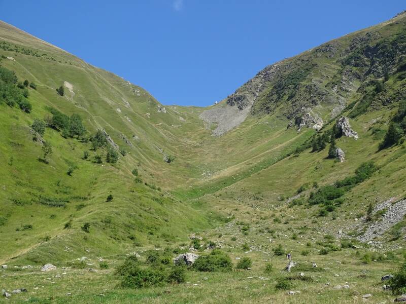
The sunrise over Lac Combal is magical. As the mountains fade from purple to gray, shimmering ribbons of water meander across the bottom of the valley, disappearing in a silent layer of mist. The glacier is bathed in the first rays of the sun and stands out beautifully against the clear blue sky. I couldn't wish for more beauty than this. Eager to hit the road, I put on my backpack again, while other hikers tie their luggage to a mule and trudge after the pack animal. At the military buildings below the Refugio I turn to the Vallon de la Lex Blanche, a valley full of grass with the sound of cow bells further on. The route is on a gravel road and I keep hiking at a brisk pace. Only at the end of the valley, when I have to climb a bit, I slow down a bit. I pass an old customs office that is now a museum and wonder how many visitors they get. Just before the Col de la Seigne I discover a pair of alpine marmots near a rocky outcrop. They scurry around undisturbed and don't sound an alarm as I approach carefully. The first animal has its butt towards me, which does not make a nice portrait. Then I discover a large specimen, lying watchfully on a rock. I manage to take some nice pictures before he or she shyly withdraws. The last meters to the col, where I enter France.Again, stuff is ready to make a UTMB food station, although I don't see any markers. To my right a bowl of mountains rises with a fascinating glacier, which is not called glaciers des glaciers for nothing. The lower I get, the better I can see it. Wow. A lot of walkers come towards me and again the bonjour sounds often. I descend to the bottom of the valley, where the Refuge des Mottetes is being prepared for another day. A little further on the path, a couple stops and looks intensely at something scuttling on the path. I follow their lead and see a young alpine marmot who is certainly not shy. When I finally walk past very quietly, he runs down a meter, but then continues grazing very calmly. Not bad. Ten minutes later I reach the hamlet of Village des Glaciers. From here, the main route is so unattractive that the high variant is the only serious option. Instead of an hour and a half on the road to Les Chapieux, I take a gravel road that winds steadily upwards. Past some cow stables a path continues into the hills. I climb up a stream until I descend a bit to cross the water. I admire a beautiful waterfall. Usually the falling water attracts attention, but here it is precisely the smooth rock, like congealed waves, that are special.I continue over a green hill and then descend slightly to the foot of a formidable scree slope. Zigzagging I hoist myself up. And higher, until I see a electricity pylon appear just over the top. Not quite the view I hoped for of the Col des Fours. The orange-brown rocks on my right are nicer and there is a viewpoint a little further. I don't give myself the time. I still have a long way to go and the electricity pylon doesn't bode well for the landscape on the other side of the brown rocks. I descend to the Col de la Croix du Bonhomme and the hut a little lower. There I rest only briefly, the many flies, attracted by the latrine, quickly scare me away again. According to the book, the next stage is an easy walk of about three hours and that’s doable. However, the path is quite rocky and you need to be careful. After the Col du Bonhomme, the French also poured fresh gravel and stones on the path, which does not make walking any easier. Although I descend all the way, it is definitely not going fast. Eventually I arrive at the Refuge de la Balme, where there is also a bivouac. I skip the first one, because I want to continue to Les Contamines, but the second bivouac is so beautifully located that I park my longing for a warm shower for a while. At the edge of the forest I pitch my tent, poodle in an icy mountain stream and eat soup with freshly picked mushrooms with a Swiss people couple.
Day 6: Les Contamines - Les Houches - high route 24 km
I couldn't have woken up to a better morning. The sky is bright blue and I am looking forward to the high route to Les Houches. But first I have to go to Les Contamines. I descend further on the gravel road, while volunteers with markers and trucks with a generator, melons and other stuff for a food station work their way up. The UTMB starts today in Chamonix, but luckily only at 18.00 hours. Before then I want to get off the route and that will be a challenge, because today is another long day.It starts with a fair bit to Les Contamines, but a river that squeezes through a narrow gorge makes it worthwhile. At a beautiful church, Notre Dame de la Gorge, I follow a glacier river into town. At another church I start to climb, steep, but easy. I leave the city past beautiful wooden houses. Initially on a gravel road, later on a much nicer forest path. Through the trees I see a city in the valley, with beautiful mountain ranges on both sides. Finally I reach the Chalets du Tuc, from where I have a wonderful view of another bowl of mountains that carries a glacier. I descend on a narrow path to the Chalets du Miage and I have not yet come across a more idyllic spot on this hike. A bowl of mountains, a glacier, a milky white river, typical wooden houses and white cows. And a path. To the Col de Tricot.Usually you approach a climb cautiously, sideways and stealthily, you first have to overcome the lesser hills and the last climb then appears like a rabbit from a top hat to challenge you one last time. Not this time. Here you are standing at the foot of a mountain and you can see people standing like pinheads on the pass, 561 meters higher. The guide suggests an hour and a half for those 561 meters and that is no exaggeration. I slowly zigzag up. The pinheads become Lego figures and then Duplo figures. It's slow, but steady. Every now and then I pause to give my heart a breather and enjoy the serene view of the valley. Two elderly ladies catch up with me, but they don't have twenty kilos on their backs. Dozens of sweat droplets later I am at the pass. I see the edge of the Bionnassay glacier and, to my great surprise, a futuristic building on its edge, a refuge for mountaineers. I descend and put back two markers of the UTMB that are loose in the bushes. As I descend I have a better view of the glacier and it is amazing. It's so quiet I can hear the ice working. What a fantastic sound. I am glad that I have the peace to hear this and to listen to the power of nature. The path continues to descend, fortunately not very steep, and I arrive at a suspension bridge above the glacier river. Now I am near the terminus of the tram line to Mont Blanc and I wait impatiently for the tourists to leave the narrow wobbly bridge. Standing still hurts my feet and on the other side I quickly climb up. Just a bit. Until I come to a pasture again, where the sound of cows unleashes a sense of calm and peace in me that I have never experienced so strongly on this trek. A wonderful day.And yet I walk on to the inevitable end of it. An easy path to the vacant Bellevue hotel follows. From there it is only a short distance to the Col de Voza, where I descend via a wide gravel road along green ski slopes to Les Houches. In the valley I see Chamonix with a very dark sky above it and a little later a rainbow. Along the route I meet more and more people from the UTMB and when I look at my watch it is half past five. Whoops! In half an hour, 2.300 ultra-runners will start their 171 km from Chamonix. I hurry down, while supporters climb up. It feels like a race against time. Although the gravel road is wide, I don't want to get in the way of the ultra runners. While the race is already on and people follow the first runners live on their phones, I reach the edge of Les Houches. A little further along the trail and I reach the point where the TMB turns left and the UTMB enters the route from the right. Now I do want to see the runners pass by and I take off my backpack while I wait for the first runners. With other admirers, I encourage the runners as they head into the mountains. After a while I realize it is getting later and I descend further to Les Houches in search of a campsite. A policeman sends me in exactly the wrong way, but two super sweet French give me a lift to a campsite that still has a spot due to a cancellation.
Day 7: Les Contamines - Les Houches - low route, 16 km
Since the ultra runners occupy the trails from Chamonix, I have planned two zeros. But then, me and rest? After one day I have had enough. That is why today I am walking from Les Contamines to Les Houches again, but this time the low route. From the center of Les Contamines I descend to the river where a forest path runs along it. At a sawmill I cross the river and continue on the other side. There is quite a bit of asphalt in this leg and I keep going. Hamlets succeed each other, including Les Hoches, birthplace of astronomer Alexis Bouvard, discoverer of eight comets. I cross the road and slowly climb up to La Vilette and Le Champel. Quite a few hikers meet me and that surprises me. The high route is so much more beautiful, had I not already hiked it, I would do so in a heartbeat. The day started cloudy and gray, but now it is sunny and the view from the Col de Tricot should be beautiful again. I follow a gravel road further up, until I descend on a forest path to the glacier river that originates from the Bonnassay glacier. Then there is a forest path up and at Le Crozat a gravel road up to the Col de Voza.From here the terrain is known, although it is now a lot quieter than two days ago. The light on the Chamonix Aiguilles mountain range is beautiful. These are not the usual mountains, softened by green grass or white snow, but harsh rock in which the layers of centuries can be clearly read. I also enjoy the peaks and glaciers on the other side of the valley. On Friday it was too late and I was too busy looking for a campsite to have a good look about me. This last piece is a second chance and I am very happy to have it.
Day 8: Les Houches - Tête aux Vents bivouac, 21 km
I saw stars early this morning. That's why I'm not worried about the clouds hanging low in the valley. From Les Houches I descend to the railway station and on the other side of the track I start the climb of 1.546 meters to the top of Le Brevent. I slowly zigzag up through the forest. Human sounds penetrate deeply. The noise of a highway, a shovel reversing, the heavy thunder of a tailgate. There is no way around it. I try to keep the noise out of my head and focus on the mist between the trees and the roots under my feet. It is getting lighter and now I regret the trees blocking my view. After a short stretch of asphalt I see a wooden fence on a rock: a viewpoint! I climb up and then it is pure joy. The cloud-filled valley beneath my feet. And the mountains on the other side. The Mont Blanc is radiant, looking innocent due to the snowy peak, but unmistakably the highest. The other peaks are just as impressive, the play between rock and snow makes them look rougher than Mont Blanc itself. Glaciers reach down to the valley, the river continues like narrow ribbons where the glaciers end. With difficulty I tear myself away from the scene and dive back into the forest. I climb higher and higher until I reach a shelter, which I quickly pass due to the bizarre high prices. Once out of the forest I have an unobstructed view and I can't help but stop and enjoy. For the entire TMB I did not know exactly which summit was the Mont Blanc and just at the point that I am closest, the mountain reveals itself in its full glory. I can see the Aiguilles du midi with its cable car and watchtower, the only place where the view of Mont Blanc is even better than from here. A narrow ridge takes me to Le Brevent, at 2.526 meters, the ideal place to marvel again at the mountains opposite. But the mountains on the other side also show their best sides. A completely different character than the Mont Blanc massif, but just as fascinating as the Grand Canyon. The cable car to the top of Le Brevent regularly delivers new tourists who settle down on the terrace after a selfie. After I've had something to drink, I continue to the lower col. The path is designed for tourists and paved with large, flat rocks. The tourists themselves have also wreaked havoc here with an extensive collection of useless, but beautiful cairns on an excellent rocky outcrop. A little lower there is an iron ladder and some separate plates protruding from the rock to put your feet on. The GR5, which has been running along for a few legs, says goodbye and I descend to Plan Praz, where both the cable car and the ski lift are idle.The path continues along the slope, gray rocks tower above me and on one of them climbers are working with ropes. I end up at the refuge La Flégère, which is closed this summer. Next to it a large building is under construction, undoubtedly a hotel. I had hoped for tap water here and am starting to run out of water. An Israeli young man on his way to the valley fills my water bladder so that I can make it to the river that flows over the path in half an hour. From the Refuge it is a bit of a search for the right route. Lac Blanc is indicated, but that is a variant that is only described in the hiking guide. Finally, based on the directions, I follow the path to Lac Blanc and not much later there is a fork to Tete aux Vents, a second peak. Just before the top I see some movement in the distance. A chamois! A little later I see two, a goat and a small one. The route passes just below the top. In the meantime it is getting a bit later and I start looking for a flat spot for my tent. A lake looks promising, but a Frenchman squeezes past me and claims the spot for himself. To my annoyance the same Frenchman comes by a little later when I am a little lower on the mountain. Eventually I find a small spot, just big enough for my tent. As dusk falls, Mont Blanc remains beautifully in sight and in impossible places, the lights of refuges for alpinists begin to twinkle.
Day 9: Tête aux Vents Bivouac - Col de la Forclaz, 16 km
The morning sun caresses the snow on Mont Blanc when I pack my tent and head up the trail for the last day of hiking. Almost immediately the path descends quickly and steeply. Wooden sleepers and thick logs are riveted to the rocks with iron bars to form a staircase. Moments later there are iron ladders straight down and even bend inwards around a protruding rock so that I hang from the stairs with my full weight. Fortunately it is only a short distance, because the steps are freezing on my fingers. There is no space to pass each other and two walkers wait patiently until I get down before they climb up themselves. Then the path continues to descend until I reach the road to Tre les Champs. The parking lot is already full of cars and both hikers and mountaineers are on the road. I cross the road and start today's first climb. The path zigzags up through a beautiful forest and the shade feels cool on my skin. Once above the tree line, I can't resist the temptation of ripe blueberries and pick a few handfuls. Mont Blanc is now behind me, but still stands proudly above its neighbors. In front of me I discover a first landmark, a dam that I also saw from the Frenete d'Arpette on the first day. I climb and climb and occasionally snack on a berry. Then I reach the top. I descend again to a green valley. Looking back, the whole valley stretches before me, with Tre le Champs and Chamonix beyond, dominated by Mont Blanc and other pretty peaks. Ski lifts await the snow here too. I climb up to the Col de Balme and then descend again to Trient. The descent is long and difficult, a gravel road full of uneven stones. Lower down I come to a forest and when the wind rolls through the pine branches, I realize how much I missed that sound in the mountains. I end up at Le Peuy, a hamlet close to Trient. One last climb to the pass. The markings of the UTMB have not yet been removed here and that makes finding the route easy. When I walk along a road, someone turns their car and offers me a lift, but no. That would detract from my walk. I chose this and even though this last climb is tough again, I enjoy it. I am a hiker.
View my pictures of this hike here.