Lake Waikaremoana (2015)
Tropical forest and a mysterious lake
New Zealand’s nine most beautiful hikes are known as Great Walks. Of these, only two are on the North Island and Lake Waikaremoana Track is one of them. Tropical rainforest, steep climbs above the clouds, wetlands and waterfalls make this hike an experience. There are also a lot of birds and you get a glimpse of what New Zealand must have looked like before the predators hit. After 46 km in three or four days, a speedboat will take you back to the start.
Day 1: Onepoto - Panekiri Hut, 9 km
The elevation profile looks simple: it takes just 10 km to climb about 600 meters to Panekiri Bluff. Beforehand I quietly thought: easy peasy. But the reality is a bit different when the van drops me off at Onepoto, the start of the Lake Waikaremoana Track in the heart of Te Urewera National Park. A small shelter marks the start of the Great Walk. On panels there’s information about the area and I pause to learn something about the landscape in which I will be walking for the next 2.5 days. The lake is relatively young, created about 2.200 years ago when a massive landslide blocked the Waikarataheke River after a major earthquake. Behind the natural dam a lake of 248 meters was created. The Moari legend about the origin is also told. The Maori chieftain Maahu-tapoa-nui asked his daughter Hau-mapuhia to fetch water for him. When she refused, he tried to drown her, whereupon she called the gods of the land to the rescue. They turned her into a taniwha, a mythical water monster for which daylight is fatal. So she tried to escape north first, and that's how the Whanganui arm of the lake was formed. Then she fled east, creating the Whanganui-o-Parua arm. Finally she tried to escape from Onepoto, but was turned to stone by the dawn. That’s where the Waikaretaheke brook is now, the only one that flows out of the lake. See, that's much more exciting than a landslide, isn't it?
Eventually I set out because my feet are itching to start hiking. Right from the very first meter the route starts to climb and I set a calm pace. The lake remains hidden behind the warm green of shrubs, deciduous trees and the occasional tree I have to look closely at to recognize it’s not a palm tree. The layered trunk exactly meets the cliché image I have of a palm and the crown of large, hanging leaves is also reminiscent of it. However, these are tree ferns. There are several varieties, some with smooth bark while others drape the brown veins of their dead leaves around them like a skirt. The grassy path turns into a narrow tunnel between the trees. A light breeze plays around my feet. Wonderfully cool on this radiant day. I see few birds, but I hear an incessant chirping like thousands of cicadas at once. This forest is so different from the Netherlands, so overwhelmingly green. The trunks are covered with thick layers of moss and ferns grow on the branches. Each tree is a world in itself. It is sometimes difficult to distinguish whether a tree is dead or alive, because even the dead ones are green still. For a nature lover this is paradise.
The trail becomes more challenging, full of roots and worn-out sand. That's how I like to see it. My throat is still a bit sore from cold I’m recovering from and climbing is not easy. Fortunately, I had some foresight planning this trip. It's some five hours to the first hut and that’s all I have to hike today. Although you can barely get lost, the path is well marked with orange triangles. That's nice, because while that first hut is still an abstract concept that will be reached in theory, the orange markers give a direct purpose. A short break at the next one pause, I promise myself, a sip of water at the second. This is the first time that I have a water bladder with me and I like it. My backpack is from the pre-water bladder era with no useful holes in strategic places and the mouthpiece dangles somewhere near my chest, just below slurping height. Fortunately the water stays nice and cool and I drink more because of my sore throat than being really thirsty. In the end I stick to one sip at a time, which I swirl through my mouth for a long time. In addition to the orange triangles, I also come across pink ribbons. I can hardly imagine they were left behind after a scavenger hunt. Anything you take into the park you have to take back with you, and I'm surprised someone found it necessary to leave a trail of ribbons. And in such a horrible color, too, which clashes with the many shades of green of the forest. For a moment I am tempted to remove the ribbons, so that the forest returns to its pure state. But then I realize that the ribbons may have a function I am not aware of, such as the red dots that indicate which trees can be cut. I leave them hang and try to look past the pink ribbons at the wonderful shapes of the trees, which form an intriguing puzzle.
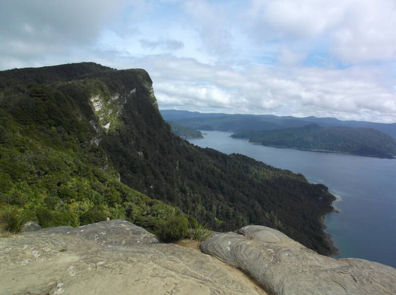
Every now and then I have a view of the sparkling waters of Lake Waikaremoana. It is no longer round, but a capriciously shaped water which squeezes between all kinds of foothills. And it is quiet. There are no boats, no swimmers, the laughter of children playing does not echo against the rocks. So peaceful. Although I know a group of five men left ahead of me on the same hike, I feel wonderfully alone in the world. After about an hour and a half I find a sandy spot in the sun with a view of the water and sit down for a while. Normally I want to reach my goal as quickly as possible, but not today. After all, I'm on vacation. I eat some raisins and close my eyes. Wonderful. In the bush above me a little bird is bouncing back and forth, without really allowing itself to be admired. Underneath a root are small, perfectly round holes in the sand and I wonder which insect lives there. When the sun disappears behind some thin clouds I put my backpack back on and hike on. The trail becomes easier now, a flat, wide sandy path winding through the trees. This is the path as it was built in 1962 by the schoolboys of fourteen different schools in a conscious effort to make this beautiful area accessible to tourists. It's a lot smoother and I'm glad I don't have to pay attention to my feet anymore. Every now and then the path goes down a bit. That's a shame. I am afraid that every meter I descend will soon have to be recaptured. But for now, I let gravity support my legs. Some hikers might find this trail boring in the long run. Only forest. I never get bored. How could it be, with so many fascinating lines and shapes about me? A natural work of art. I wonder what Escher would make of this. Quite a few trees along the path are showing black scars from lightning strikes. The wood here dies red, not the hard gray of dead wood in the Netherlands. The earth on the right, where the path was excavated, also shows all kinds of colors. A New Zealand wood pigeon flies across the path just in front of me, showing a beautiful fluorescent tail. He stays for a while, but on a branch it’s just a large gray pigeon again. Another gray, fluffy ball can be viewed. Some kind of tit, I suspect. Could this be the gray warbler? Or the fantail? And every now and then there is the sound of a bird I can’t see, reminding me of an oriole. Unfortunately he is as shy as the oriole and although I try to locate the sound, the singer remains well hidden. There are no benches along the route and by the time I get hungry, I drop my butt in the grass somewhere. I eat something and close my eyes again. Wonderful, dozing off so undisturbed, knowing that no one will come along as a silent admonition to urge you to keep going. After a while it gets cool again and I continue. It doesn't take long before I get to a fork in the trail, where a sign points towards viewpoint Bald Knob. I take a look and it's beautiful. The army of dead birches on the way to it, then rocks giving a fantastic view of just about the entire lake. As far as the eye can see, the green mountains merge, becoming more misty as they hug the horizon. There is no town, no village, no house to be seen. Where does that ever happen in the Netherlands? On the other side, away from the lake where the hills are brown and probably sheep and cows graze, no sign of civilization as well. Except for one road, but I can live with that. According to the sign it is still an hour to the Panekiri hut. Maybe I'm getting tired, but it's a long hour. Eventually I come to a wooden staircase that leads to the hut. A small, vandal-proof thing with bunk beds, mattresses and a number of benches and tables. Rainwater comes out of the tap, which is collected in large barrels from the roof. It is safe to drink, according to a sign in the cabin, but if you don't trust it you can still cook it. First I go outside. Because here again, at the highest point of the route, there’s an amazing view all around. And also a patch of grass in the shade that calls my name. Backpack off, shoes off. I don't need to hike any further today. I give in to my laziness and enjoy myself. What a wonderful vacation.
Day 2: Panekiri Hut - Marauiti Hut, 20 km
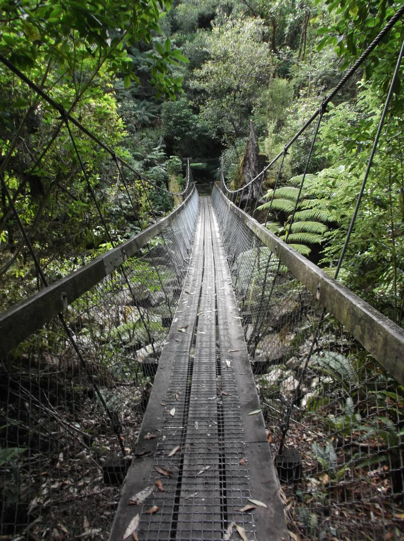
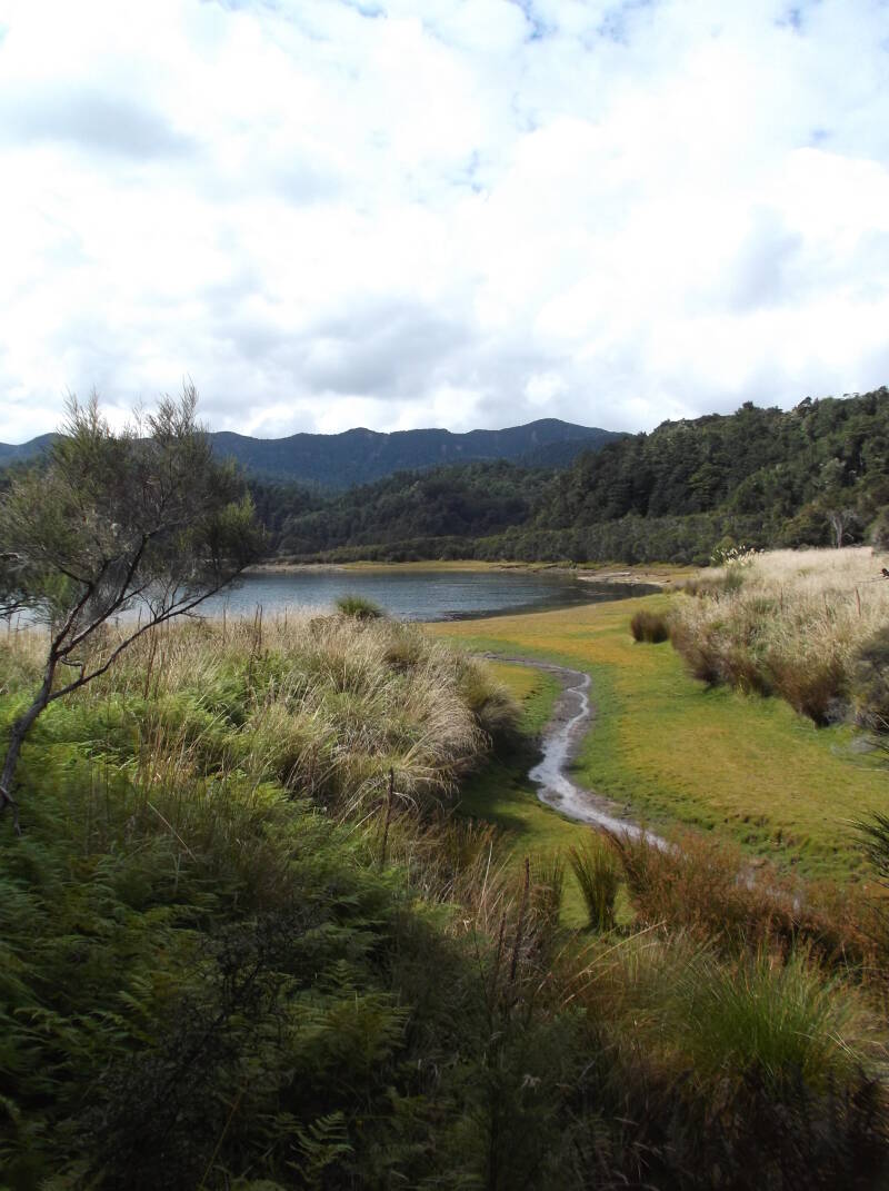
The morning starts magically. The lake is covered with a cotton ball cloud layer, which lies quietly at my feet. Shards of clouds skim through the treetops, like white ghosts dancing in the wind. While the sun is rising, I head out, because today is going to be a long day. A few meters from the hut and you are already in the forest, what a treat! The path remains wide and easy to hike and I set a brisk pace. I descend very gradually, with the occasional climb of a few meters, just to tease. Then I come to a staircase which brings me about 250 meters lower in one go. I'm glad I don't have to climb it. Halfway up, at the bottom of a wide rock, I stop for a moment. The gray of the stone is not visible, softened by moss and ferns. Where they can find support is a mystery to me, but it lives exuberantly. It is still nice and cool under the trees. Although it goes smoothly, I start to look for a place to rest. When the moss rises, I stop for a moment and enjoy the dried apricots I brought as a snack. Because I left a book at home because of its weight, I remain a bit restless and quickly move on. I continue to descend until I am almost at the water, where the landscape changes completely. Much more open, with grass and reed. The sun burns my skin quite a bit and I ladle up with sunscreen. It doesn't take long before I reach the turn to the Waiopaoa hut, where I enjoy the beautiful view for a moment. A sandy bay full of ducks, a little blue heron settles down. It does not have that yellow beak which gives the Dutch blue heron such an aggressive appearance. Huge plumes of reed above my head. I follow the grassy path to my first suspension bridge, which happily dances up and down a muddy stream. The path meanders alternately through forest and grass. The trees here are different, bare, gray trunks with a tuft of green at the top. Every now and then there’s mud and I enjoy even that.
After hiking along the lakeshore for an hour and a half, I come to the trail to Korokoro Falls, a side trip of no more than an hour. I am curious and put my backpack next to the path behind a tree fern. I only take a water bottle, my camera and my trekking poles. Wonderful to be able to move freely again without all that weight on my back. The path is longer than expected, but adventurous. Nicely climbing over tree roots, jumping across a brook. To the right of the path, in the depths, water begins to gurgle, a sound I have missed on my hike so far. On the way I meet quite a few other hikers. Apparently this is a popular trip. Then I come to a stream and the only way to the other side is across rocks of all shapes and sizes. Stepping stones is too good a word for this collection of boulders. To help hikers, there is an iron cable you can hold on to. Fun! From there it’s not far to the waterfall. The water falls lazily across a square rock. Despite rain for the past few days, the waterfall is limited to the sides of the rock. On the right side, a reliable stream tumbles down, while on the other side it looks more like a decent leak. I can imagine that after a heavy rain shower there’s a real curtain of water, but today we have to make do with the net curtains. The rock itself is a flat wall with a large crack at the bottom, covered with different shades of moss. So much color! Red and green and black. There are a few people at the base of the waterfall, but I enjoy my view from above. The view from below is probably no better and I don't feel like getting wet. It's time to go back. The way back seems shorter, but isn't it always so? I pick up my backpack, but don't hike on immediately. Two minutes away is the Korokoro camping spot. I hope to find a number of things there, such as a latrine, fresh rainwater and some rest. It’s an idyllic spot on a bay, but I do not find peace. There are too many wasps and other small critters flying around, including stuff that bites. Are these the infamous sand flies? In addition, animals have grazed here and left their excrement in the grass. Still, it takes an hour before I gather the energy to continue. I'm lazy and don't feel like hiking. I drag myself up, because tonight I want to sleep in a cabin again and not in open air. Slowly I get going. Of course there are things along the way that fascinate me and give me new energy. A tui which I can view very close up. His beautiful white band of excellent show feathers. The fluorescent green back. This is the bird whose sound reminded me of an oriole. It flies to a branch to eat some berries, where I can see it very well. Beautiful! A fantail can also be admired up close, which takes its name from the tail that it unfolds like a fan. For a moment I am completely happy. The path follows the contours of the lake and one bay after another passes by. Every now and then I cross a brook that has been entrusted with water to the lake. At a certain point I start to get tired. I rest for a while and then move on. Finally I reach Te Kotoreotaunoa Point, where the path turns inland along Maraunui bay. On the other side I see a hut, but from the directions I know that today's end goal is not close yet. That hut is for Department of Conservation staff. The trail continues for kilometers along a brook until I reach a bridge and then return along the other side of the water. I notice from the grumbling in my head that I’ve really had enough for today. Dried apricots do not provide enough energy to last me a whole day. Fortunately I don't have to climb anymore, I think, but I’ve cheered too soon. There is another steep hill between me and the hut. Slowly I climb the tree roots, hoist myself up on my trekking poles. On the other side I descend again, this time without roots. I end up in a tree fern forest where the trees are so big and close together that it’s dark. I will only stop when I see the hut and with the finish in sight I use my last bit of energy. Two more minutes on a grassy path, the signpost promises. And then finally there is the wooden staircase to the veranda, the familiar bunk beds and the cooking area. I throw off my backpack for the last time today, pull out my sandals and towel and jump into the wonderfully cool waters of Lake Waikaremoana. Great, what a wonderful swim! The water is cold and full of itchy seaweed, but swimming a few laps is super refreshing.
Day 3: Marauitihut - Hopuruahine Landing, 16 km
Again I get up just after sunrise. This time not for a very long day, but one with a fixed deadline of 2 p.m. At that hour the water taxi will pick me up at the terminus and because I love punctuality, that time is in my head almost all morning. Only when I get to the last cabin and have another hour and a half for a 45 minute walk I relax a bit more. But first there are those extraordinary, fantastic kilometers through the forest. The forest itself continues to be enjoyable, as if you were walking through a tropical zoo, but without prams. And without birds, I realize. Only now, in the early morning, does it strike me how unnaturally quiet the forest is. In the Netherlands, the forest would literally sing, from blackbirds and thrushes defending their territory to red breasts luring a mate and a woodpecker drumming on dead wood to achieve the same. At most a single tui can be heard here. This is what happens when you treat nature thoughtlessly. Pure poverty. When New Zealand split off from the primordial continent of Gondwana, there were no mammals in the country except for two small bats. Except for a few birds of prey, the New Zealand birds had no natural enemies. This allowed them to nest safely on the ground or in tree holes and flying was actually no longer necessary. The Maori brought the first enemy, rats, but the English made an even bigger mess. First, they brought rabbits to kick-start the fur industry and they reproduced like… rabbits. To combat that plague, they released possums and ermines, unleashing an even greater disaster, if possible. For the predators quickly realized that the birds were much easier prey than the quick-footed rabbits. Birds without flight instinct, which remained motionless when threatened. Of the 107 native bird species, 35 are now extinct and 25 are critically endangered. That is almost half! With so few tui left, they do not have to defend their territory and it is no longer necessary to raise their voices. Here and there along the route I come across traps and last night hunters with big guns and an illegal spotlight walked past the hut. But judging by the deafening silence, the Department of Conservation has a long way to go. Yet there is plenty to enjoy even without birds. The forest remains a feast for your eyes. So intensely green. Today there are more rocks on the path, which I get to climb around and over. Every now and then a small stream drips across the trail and across the larger streams there are wooden bridges. The larger brooks have large suspension bridges, which still sway in my legs when I have already reached solid ground. Although I cannot imagine that the weedy streams are really responsible for the amount of debris along their banks. Branches, complete trees. Maybe if it rained for a week. The trail largely follows the water, with the occasional foray inland to traverse a peninsula. Near the water the path is muddy and I step on the branches that have been put in the worst puddles. Every now and then the path is paved with pebbles, but after two days of soft forest floor the pebbles feel hard and uncomfortable. On the water I see countless black swans which make a sound that reminds me of rubber ducks. Black swans are native to New Zealand, while white ones do not thrive there. Very odd. After about two hours, I reach Waiharuru Hut, the largest and most modern hut on the route. Now there is no one, but 40 people can sleep here. I am hiking in the late season and so far it is fairly quiet in the huts, yesterday there were four of us. In any case, I suspect that this Great Walk, included in the list of nine most beautiful walks in New Zealand, is not the most visited. Still, I am glad that I am not completely alone, even though I consciously chose this quiet time. After a short break I cross Upokorokoro Stream and then I have to climb again. It is only a hundred meters, but my legs still struggle and I am glad that the poles take over some of the weight.Here I also come across a fence that is live and keeps kiwis in the Puketukutuku Range peninsula. The area has been reasonably cleared of possums and the young can grow up safely within this fence. If there are 250, it will be removed. But they are not there yet. The kiwi turns out to be a nocturnal animal and the secret hope of encountering one evaporates. In addition to the familiar orange markings, pink triangles start to appear again. This time with an explanation: there’s a line of rat traps. I'm glad I didn't remove the pink ribbons on day one because like possums, rats are one of the many pests that threaten birds. Again, I feel it takes longer than it should before I reach the next hut, the Whanganui Hut, although my watch contradicts my feeling. It took me exactly two hours and that is the time suggested. This hut is a small and cozy place and just as empty as the previous one. I do meet two hikers who were dropped off by the water taxi an hour before. The collection point is 45 minutes further and I still have plenty of time. I continue slowly. The end is approaching so quickly. I'd like to hike on forever, around the whole lake. But on the other side of the Whanganui Inlet I already see a campervan. The way back to civilization is close. Fortunately, first I get to enjoy a boat trip. The water taxi, with its two powerful engines, soon shows up and takes me back to Onepoto at an breakneck speed. So strange to be out of the woods again. I know where I prefer to be!
View my pictures of this hike here.