Fjordruta (2024)
Beautiful views and lots of wet feet on the Fjordruta
After a whole day of walking through mountains and swamps, you arrive in the evening at a cozy hut and build a fire in the stove. You put your shoes out to dry and look in the pantry for something tasty. Solbeartoddy, chocolate milk or tea. And cookies of course. The 154 km long Fjordruta starts right at the airport in Kristiansund and ends in Halsa, from where you take the bus back to the start. A wonderful experience, Norway at its most beautiful.
Day 1: Kristiansund – Trollstua, 9 km
After purchasing the keys to the DNT huts at the Tourist Information Office in the center of Kristiansund, Ingrid and I take the bus back to the airport, where the Fjordruta officially begins. Surrounded by alluring green mountains, the airport is located a little way outside the city and as soon as you start walking, you are in nature. From the first marker at the entrance to the airport it is only a few hundred meters walk, past the long-term parking lot and a small quarry, before turning onto a gravel road that winds up a hill. The gravel road ends, the hill does not. Wooden posts with a red head indicate the route, straight through the bushes. Apparently this is not a very popular path, because there is no trodden path in sight and the bushes scrape against our full backpacks. Ingrid sleeps in the huts, but I want to test my equipment for New Zealand and go camping. Moreover, I have at least ten days' worth of food with me, the longest stretch I will have to cover in one go on the South Island. My backpack is heavy, but I can handle the weight and love being in nature again. The climb is short, but not too intense, the hill being only 111 meters high. Then we walk into a pine forest and start a descent that is much longer than the climb. This first stage is not said to be difficult and although it is not technically very complicated, you do have to pay close attention to your feet. While a plane takes off behind us, we follow the path for short stretches up and especially down. It is quite warm and there is no wind, so drops of sweat quickly rain on my glasses. A moment later we see a yellow fuselage of the plane rising above the trees, its nose pointed towards the sparse clouds. Fortunately, Kristiansund is no Schiphol and it stops with a single aircraft.
Every now and then there is a patch of swamp where the path disappears and only posts indicate the direction. We find the best way to avoid wet feet. Under my feet I even see sundew, the carnivorous plant, two species of which are quite common in certain places in the Netherlands, but are still on the red list.
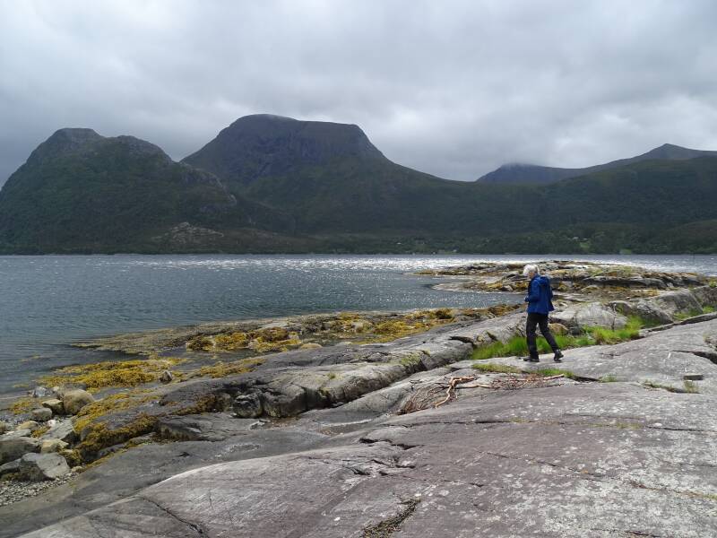
The descent ends on a gravel road where a lady walks her dog. We follow the road up a steep hill and then cross a bridge into a rocky landscape. We walk back towards the forest over the bare, gray stone with its cairns, until we see the wide water of the Talgsjoen. We meander up and down along the edge of the fjord. Some rocks have a rope to help hikers descend, but I just slide down on my butt. By now something is starting to rub on my foot and we pause for a moment to tape up my Achilles tendon. The unplanned break is actually quite nice and we enjoy the sun on our skin, the silence, the heavy smell of the forest. After one last stretch of forest we step onto the tight grass of a golf course, where dandy looking men are about to hit their balls. On the other side, a short path leads to the ferry pier, where the previous boat has just left. Fortunately, the ferry runs every 20 minutes, so we don't have to wait long. Soon the ship approaches and a long line of cars emerges from behind its raised bow. There are a lot more than seem to fit in the ship, where do they all come from? When the last car is on shore, we walk onto the ship. There is no outside deck, but we don't mind, distracted as we are by the coffee corner with soft drinks and all kinds of goodies. But first we want to pay. We approach a crew member, who looks at us in surprise: the crossing is free for walkers. We make ourselves comfortable, quickly charge our power banks at one of the many sockets and look through the dirty windows at the passing rocks on the other bank. A few houses, a boathouse, more rocks. We soon arrive in Tommervag and continue on the route. There is not much traffic and we walk along the road through the sleepy village. Not much further we dive into the forest again, lovely narrow paths that have not been flattened by thousands of heavy feet. It is not too difficult and this time we soon arrive at a forest road that we follow until the signpost points to the hut, a lot higher in the forest. After a final climb we stand next to the large wooden building surrounded by trees. There aren't many flat spots, so I pitch my tent right behind the outdoor shower. Ingrid is looking forward to it, but unfortunately, there is no water. After looking at the hut, we walk down to Lake Bornavatnet with empty jerry cans in hand to get water. Ingrid washes herself for a while, but I find the water too chilly for that. Once back I filter the water and then we cook our dinner. We don't make it late.
Day 2: Trollstua – Gullsteinvollen, 9 km
After a lazy morning we start walking at 9:15 am. The air is soft and it is not as warm as yesterday. We walk behind the hut to the latrine and then bend towards some fresh beams that carry us over the boggy ground. There is even something of a boardwalk made, although it looks more like a flat staircase than a real boardwalk. The route runs along the banks of Bornavatnet, where we discover some holiday homes. A section of forest later we arrive at a gravel road, which first runs along an arm of the Jorenvagvanet and later along the large lake. In the water there are small islands covered with moss and slender pines. On the other side of the lake, rocks tower high above the water. And in the forest next to the road, a low waterfall bubbles down along black rocks. Even though it is a gravel road, we are not bored. The hiking is easy, there is plenty to see and our ears are not yet so used to the silence that we no longer notice it. We follow the road for quite some time, until we arrive at a parking lot. No doubt another holiday home is hidden somewhere further away, we only see a boat along the shore, waiting for playful children or perhaps serious fishermen with fishing rods and nets. Our path continues into the forest, a green cart track that rises very gradually. The path becomes narrower, forest and ferns alternate. Water bubbles in a gutter along the path. Then the route suddenly dives into a pine forest, the red markings a nice contrast with the brown bark and dead needles on the ground. Every now and then the route weaves up and down, but the trend is still upward. The last part to the tree line is a bit rocky and we have to pay close attention. Then we rise above the treetops and have a beautiful view of the fjord behind us. A dark sky above dark mountains and dark blue water. It starts to drizzle and we turn back to the pass. The posts with a red head show us a way through a swamp, where we do our best not to crush the sundew with our clumsy feet. Grass, mud and delicate flowers alternate. Ingrid stops briefly to put on her rain gear and I continue to the pass between the 857 meter high Jorensvagsaken and the 896 meter high Skalen. The route goes up very gradually, but I hardly notice it. After the Tour du Mont Blanc and the GR20, I am no longer impressed by a tame climb like this. The wind is blowing quite hard at the pass and we don't delay for long. On the other side we start the descent, which is not very steep or very technical, but still requires the necessary time and concentration. We have a beautiful view of the valley that stretches before us. A gray sky promises rain, but ahead it is dry and windless. Water flows from a rock covered in slimy moss into dozens of small streams. We slowly get lower and lower, into a landscape of rocks and mud. At the tree line there is long grass and swamp, which we can stroll straight through. Luckily I have my hiking boots on and my feet stay dry. Until just before the hut there is a swamp area and we meander from mud puddle to clump of grass with the occasional stream to jump over. Eventually we arrive at a cart track and we follow it in a straight line to the hut. A turnoff takes us to Gullsteinvollen, where a mountain biker has just arrived and is considering whether to stay or continue. Outside the hut I put up my tent again. In addition, I am assaulted by small midges, so that my face resembles a pincushion for the next few days.
Day 3: Gullsteinvolllen – Imarbu, 14 km
Bad weather is forecast for today, but apart from a strong wind it is not too bad. A gray cloudy sky hangs menacingly above the forest, but for now it is dry. Just after 9 a.m. Ingrid and I go out. We follow an unpaved cart track and after about 2.5 km we are allowed to enter nature. We follow the red markers through a series of soft swamp, rocks and lots of forest, but it is not very difficult. Finally we reach the road, near the hamlet of Gullstein. An intersection with a church, a cemetery and a few houses, it is not much more. We no longer see any markings there, but the route is self-explanatory, because there is only one bridge over the water to Stabblandet. The view from the bridge of the Salasundet is fantastic, although we are almost blown off, the wind is so strong. Along the shore of the island we see eagles flying with their characteristic white heads. After the bridge we take a shortcut to a quiet gravel road past some farms, after which we can enter the forest again. There are narrow forest paths through open pine forest with a carpet of blueberries, but also stretches of swamp, where mounds of white moss have wrapped themselves around the base of young trees. There are some small bumps and we cross two roads before we can really start climbing to the Nauthattan. It is only 170 meters high, but after a few normal climbs we come across a few real scrambling sections along an impressive rock wall where we hoist ourselves up with our hands and knees. Just then it starts to rain heavily and while Ingrid puts on her raincoat, I keep walking. At the highest point the wind rushes through the pass at breakneck speed, but fortunately I am already in the forest, where it is less intense. The descent is also less steep than the other side of the mountain, although you still need to pay attention. I find a windless spot and wait for Ingrid, who is surprisingly close behind me. After a short break we continue. At one point we get off the route for a moment, but with GPS we know where to look and discover the next marker. Eventually we get back to the road and there is a bridge back off the island. After a second bridge we turn onto a gravel road that, after a kilometer or two, leads to an Imarbu hut, which is beautifully situated on the Imarsundet fjord. Just past the low boathouse is a campfire area with benches around it that offers a view of the fjord and the rocks with their orange seaweed over them. It's beautiful. It's very windy, so I choose to spend the night in the hut today, because the tent will undoubtedly be too noisy. In the hut I have an entire dormitory to myself. Although the hut is located on a road, there are not very many people. Yesterday there was a group of 20 Germans, but now there are at most two couples and us. I make myself comfortable in the dormitory. The curtains barely keep out the daylight, so I hang two duvets over the curtain rails, so that it becomes wonderfully dim, and choose the bed in the darkest corner. I sleep wonderfully and wake up well rested.
Day 4: Imarbu - Nersetra, 13 km
The wind has died down and the weather is wonderfully mild. Ingrid covers my heels with sports tape, because I have been suffering for a few days and it is not getting better. We go out quite late at 9.30 am. We follow the gravel road uphill for a while, where we have a view of the fjord. We pass some houses and then enter the forest, where a barely visible path stretches out in front of us. Wooden posts with a red head show us the way through the forest, the areas of peat where we cannot avoid stepping on sundew and through stretches of long grass. Although the route is marked idiot-proof, I still manage to lose the route. I no longer see any markings, but I do see a clear path and here in the wilderness there can't be two paths, right? When the path dead ends in a field of tall ferns, we decide to go back to the last marker and indeed, here we should have turned right, back to the gravel road. We follow it for a while until we cross an asphalt road and enter nature again. This time there are lakes and streams between the swamp areas, a bridge made of round wooden poles and stepping stones. The route undulates up and down along a lake and then dives back into the forest, over hills. We take a half-hour break on a dead tree stump and that does us good. The silence is noticeably loud and we are surprised that we do not encounter any other hikers. Then we continue and my feet feel better now too. The soil is soft and that helps. The descent to the road is quite steep and we crawl down. We hear goat bells, but I can't figure out where the sound comes from. Once on the road we look out at the head of the fjord, a small island in the water. From here it is about three kilometers to the hut. I put on my slippers, because my hiking boots, which fit perfectly last year, are now half a size too small and my toes are letting me know it. In the slippers my foot has plenty of room again and that is wonderful, although the tendon of my arch is also a bit overloaded. But I can't do anything about that now. We follow the road around the point of the Foldfjorden, the walls of the fjord adorned by a handful of meadows and farms. We suspect that one of them is a farm shop, but when we enter the yard, it turns out to be closed. Just as we walk back to the road, a truck arrives. The owner or a helpful neighbor? She fishes the key out of the milk barrel and we buy something tasty. Delicious. We then follow the road for a long time, until we turn off and climb a hill. The hut turns out to be an old house, with black and white photos on the wall and a sofa with elegant cushions. It really is a DNT hut, with hut shoes next to the front door and a pantry with that delicious blackcurrant juice that you drink warm. And with electricity. Soon the stove is roaring with cheerful flames again. I pitch my tent in front of the hut and have a beautiful view of the fjord. In the evening, does walk through the field, but they quickly flee into the forest when they see us.
Day 5: Nersetra - Aure, 7 km
We set off again in a fairly relaxed manner and immediately start climbing from the hut. Not very steep, but gently through a wide lawn in the forest. It is sunny and warm and I hope I have enough water with me. Ingrid stops to tape her toe and the unplanned break is wonderfully relaxing. There is no sound, no cars, no planes. Just the birds and our own breathing. After the short stop we continue, always ascending over soft ground, swamp and peat. The red posts invariably show us the way. A green mountain towers high in front of us, but we turn off onto a path in front of it. We slowly approach the tree line and the gray rocks become more numerous. We pass a last pine and then there is the ridge. From there we have a great view of the fjord with its numerous islands and on the right we see Aure nestled against the hills. We take off our backpacks and enjoy the beautiful world around us cooled by a gentle breeze. I walk to a rocky point from which I have an even better view of Aure, which is located on a beautiful fjord. We see the graceful bridge that we will have to cross later. Two sheep come and stand on a distant hill and look at us curiously. We descend gently and gradually through a swampy area full of beautiful lakes. Then we descend more steeply over an old jeep track, although I can't think of any reason why anyone would ever go up here by car. For the first time, we meet hikers, a father, mother and son, day hikers who float up unhindered by heavy backpacks. Ingrid is surprised, until I notice that it is Saturday. Of course people are outside in a landscape as beautiful as this.
On the way down I just see a fat snake darting away in the tall grass. Ingrid must have walked right past him. Based on the brown diamond pattern, I think it was a viper. My toes start to hurt again and I am happy when we finally reach the asphalt road. Here we cheat and call a taxi to Aure, who was apparently already in the area, because he is there within 5 minutes. According to the hiking guide, the 5.5 km to Aure would be too dangerous, with not only bridges but also tunnels along the way. In retrospect, I think it wasn't too bad, although there is not always a shoulder or emergency lane on the road. The tunnels have sidewalks and as a walker you can easily get through them. But the long stretch of asphalt would detract from the enjoyment of this beautiful day. Now we can just relax and enjoy our beautiful memories. In Aure we check in at the guesthouse and immediately use the lovely hot shower to rinse off the dirt and sweat of the past few days. We do laundry, so that we have wonderfully clean clothes again. Then we look for an outdoor or shoe store. Unfortunately, I overestimated the size of Aure. There is a small shopping center, but it consists of a clothing store, a pizzeria and a small supermarket. So I have to make do with my tight Meindels for the rest of this holiday. Fortunately, there is also a larger supermarket and they have more than enough sports tape. We laze the afternoon away on the terrace overlooking the fjord and enjoy a delicious meal at the hotel. What a treat.
Day 6: Aure - Rolvangen, 10 km
We start the morning lazily because it rains heavily during breakfast. We don't go out until around 10.30 am. Ingrid has taped up my right foot again so that I hopefully have less trouble with the tendon plate and I am only wearing my socks liners to give my toes a little more space. It feels good and I go out more cheerfully than the past few days. We walk through the village and only stop at the school to take off our coat, because it is warmer than we thought. I take a quick photo of the beautiful mural, an abstract portrait perhaps, and turn into a street that ends at a narrow forest path. The forest area is fenced and out of the corner of my eye I see something moving. That round face, a moose! It's a female and she runs away quickly. A little further on we pick up the Fjordruta again at a stile over the mesh. On the other side there are planks, because the ground is quite disturbed. It's easy and we soon reach the second stile, leaving the fenced area again. We dive into the forest and the path winds slightly up and down, but does not rise significantly. There are also red ribbons along the route that are reminiscent of an ultramarathon. It starts to drip, but because we are just walking into a dense pine forest at that moment, we don't notice much at first. When the rain continues, I put on my rain kilt and wrap my camera in a plastic bag. They can only be taken off again ten minutes later, when we emerge from the forest and have a beautiful view of some houses stuck on the opposite mountain slope. Before we get there, we turn to a cart track full of stones. Higher up, the path is reinforced with tree trunks and they are super slippery. And yes, I fall, luckily without anything breaking. The path winds on, ever upwards and never boring. Every now and then there are moss-covered stones, but of course also the bits of swamp where we have to choose where our feet are least likely to get wet. As we ascend higher, the area becomes more open and looking back we see the fjord with its islands and the graceful bridge. Even higher it becomes misty, or cloudy, and the trees stand out starkly against the gray background. We take a short break, but the weather does not invite us to sit for long. We walk further towards a hut where some sheep graze. I also hear something to the right of the path, but I don't recognize the sound. I see a brown patch running through the heath, a fawn joining its mother. Wow. Now we start the second climb of today, which is a lot longer, but not very steep or difficult. The higher we get, the more rocks appear on the path, over which streams suddenly flow. The clouds hang lower and lower until we walk into a gray world where the wind blows strongly. It's not annoying, it's dry and that's the most important thing. There is not much view and we walk from cairn to cairn. The play of gray stones, rushing clouds and the green grass and moss is beautiful. The path winds over the flanks of Mount Rostolen, quite long, until we start to descend. Suddenly we come under the clouds and the landscape regains its clarity. In the depths we see the lake just next to the hut, and in the distance the fjord. Beautiful. We have the cabin all to ourselves again and I don't even think about putting up the tent. Ingrid lights the stove and I chop some wood into smaller pieces for kindling. Then another relaxing and lazy evening in the hut.

Day 7 Rovangen - Storfyskhutta, 12 km
What a beautiful day to be a hiker. One of those days where I feel truly privileged to be able to do this, to be here. Enjoy every kilometer.
The morning starts mild and windless. From the hut we climb up over the flanks of the Pikfjellet. A green landscape without trees and shrubs, but with sheep in the distance. We walk a little too far, get off the route again and have to go back a bit. When I walk forward, the route suddenly turns right and I have to continue a bit higher. “It's easy to go wrong here,” I still think. A little later I see Ingrid walking straight ahead thoughtlessly over a rock some distance below me. Oops! Crossing is not possible in this swampy landscape, but fortunately she does not have to go back very far. We cross the saddle and on the other side we can climb again. Based on the map, I thought we would turn onto the peninsula and not see any more fjords, but in front of us there is an elongated stretch of water with a graceful arch bridge. We get higher, rocks, grass and water together form a beautiful coastline against the backdrop of merging mountains. There is even a bit of snow left on one of them. We hear plovers calling around us and when one comes close enough I see that it is a golden plover. A few marshes further, Ingrid startles a ptarmigan. The female runs in front of us and occasionally flies up a bit, how special. We ascend and descend, but not particularly crazy height differences. Then we come to a second mountain on a beautiful saddle full of lakes wedged between the gray rocks. It is breathtakingly beautiful. We follow the water over the rocks. Ingrid slips on a wet rock, a black, slimy spot that I had consciously avoided. Then we descend again through low bushes. The ground is very wet and we need a break, but we continue walking until we encounter dry ground near a pine forest. A bunch of Germans come towards us, with heavy backpacks and without trekking poles. Unexpectedly quickly they disappear from view again. Rested, we continue, ascending and descending over the hills. After a narrow path full of curved birches we arrive at a river that we carefully cross using stepping stones. Further than. We see a hut, hope it is ours, but we have to go another kilometer for that. My feet are starting to hurt, despite Ingrid's extra tape. A final edge then, a last stretch along a lake and the hut is suddenly very close. Delicious.
Day 8: Storfyskhutta - Sollia, 10 km
A bright blue sky and a sun reflecting on a ripple-free lake. Today will be a beautiful and especially very warm day. Ingrid tapes both my feet today and just after 09.00 a.m. we set off. We follow the posts with red heads over the flanks of the mountain. It is very swampy and we find our way through the peat and from stone to stone. The path winds up and down a bit, but not dramatically. When I walk a bit ahead, I almost step on a small adder, as thick as my finger and at most 30 cm long. It makes some attacking movements with its head and then disappears into the grass. In the depths a lake appears with two wooden huts on it, one on each bank. We walk past them through the low bushes and then arrive at the turnoff to Sollia. Here you can choose, a short route or a long one. The long and more difficult route goes directly to Vinjeora and the next hut, Sorelisetra. The short and easier route first goes to Sollia, a hut that, based on the map, is beautifully situated on the edge of a fjord. It is precisely that hoped-for view that is the reason we choose Sollia. We follow the markings up along a nameless river that tumbles over rust-brown rocks. At one point we cross the water via stepping stones. I take the opportunity to filter some water and wet my head. Wonderfully cool. We follow the river upstream for a while until we turn off and follow the Raudbekken, from waterfall to waterfall. And that goes up. Fairly long and strong, although not very steep. Higher and higher we climb, until the undergrowth makes way for grass and moss and the rocks take over. It is warm, I sweat and drink and toil upwards. Fortunately, it is not too long or too hard. We reach the top of the Snofjellet and descend slightly to a spot sheltered from the wind. There we take off our backpacks and eat lunch, for me a wrap with salami. We stretch out on the moss and take a lovely nap in the sun, which is occasionally dampened by a cirrus cloud. After having lazed around for such a lovely hour, we hoist ourselves up for the last stretch to the hut. A landscape of lakes, marsh and rocks stretches out before us. There is not always a path, through the sopping peat we walk from stone to stone, marker to marker. Then the descent begins, which is much less steep than I had expected based on the map. The entire landscape looks different than expected. Much greener and we get much lower than I thought. We see green meadows and houses, but that turns out to be on the other side of the Vinjefjorden. We descend further through a birch forest, until the hut suddenly appears around the bend. Beautifully situated, on the edge of the mountain slope and with a view of the deep blue water of the fjord, the green fields and the houses on the other side. There is even an outdoor shower full of lukewarm water, which we eagerly use. The hut is dark, with only a few windows and a large, stone fireplace, which we light to dry our clothes and shoes. We have the hut all to ourselves again, fantastic.
Day 9: Sollia - Storlisetra, 13 km
The fjord is completely covered and it is raining softly. The app indicates that it should dry up around ten o'clock, so we turn over and have a lie in. After tidying up the hut, we hoist our backpacks on and set off. Every now and then the fjord is visible again, through gaps in the clouds we see the water. The route starts with an easy grass path, but after ten meters it becomes narrower and we climb up through a birch forest. Every so often there is a piece of open marsh where our footsteps cause a small flood wave as we press the water out of the moss. We climb quite a bit, through pine forest and over open plains. We come to an area where rocks and marsh alternate, but in any case it is flatter there and we make good progress, although we do not make the 2.5 hours stated on the map for this section. We pass quiet lakes with graceful water plants and cross a few streams with stepping stones. Occasionally we have to search for the route, but we always find the next marker. I get quite warm and quickly take off my coat.
At a hill a bench has been made with stones and we rest for a while. Refreshed, we continue. Over the hill is a large lake in which a group of children are swimming. The sound of their laughter and screams carries far. We leave the children's party behind us and descend steeply through the forest. Here and there in the bushes we come across papers with the questions of a nature quiz for the children. After a last stretch of grass we step awkwardly onto the asphalt of Vinjeøra. We already knew that there is no café or restaurant here, but we ask anyway to be sure. The Norwegian woman reacts enthusiastically and invites us for a cup of coffee or a soft drink. I never thought I would voluntarily drink Pepsi Max, but in this heat I pay more attention to the carbon dioxide than the taste. After a little hour of chatting we continue down with fresh reluctance, we have to get going and the groaning is in the air. But when we see the fjord stretching out in front of us, the blue water and the mountains merging into each other, all discomfort is forgotten. This is why we came to Norway. Jotunheimen may be popular, but the fact that we are the only hikers here makes it extra special for us. As if we have discovered a hidden gem all by ourselves. At a parking lot next to the closed restaurant we go to the toilet and I lather myself with suntan lotion again. We cross the road and take a gravel road that winds around a farm into the mountains. The road becomes narrower and greener. Countless signs point to other, unknown destinations, huts or lakes. We faithfully follow the red T. The last bit goes steeply up through the forest and soon we see the square shapes of a hut and an outbuilding. The hut is small and cozy and is located in the middle of the forest, but still catches enough sun to sit on the veranda. That makes us nice and lazy. There are many blueberries and I pick a handful of ripe berries to brighten up our food. We get water with buckets from a water tank that has been built in a stream a little further on. The water there is full of leaves and bits, but we filter that out. We have the hut cozy to ourselves again, such luck.
Day 10: Storlisetra - Grytbakksetra, 11 km
Today it threatens to be 26 degrees and that is why we set off half an hour earlier than usual. The sun quickly makes the few clouds disappear and burns happily. We start climbing right from the hut, through a pine forest full of blueberries. Higher and higher we go, while the trees become smaller until they are no more than knee-high bushes and later branches that grow flat on the ground. When we are above the tree line we see the fjord with Vinjeøra in the distance. We look to see if we can see Sollia on the opposite mountainside, but that is a hopeless task. I sweat profusely and regularly stop to catch my breath. I drink a lot, before we have even reached the highest point, I have already drunk almost half a liter. Fortunately, we do not have to climb any real peaks this time. The route grazes the 8770 meter Knuppelfjellet and continues over the flanks of the slightly lower Fossdalsfjellet. A stream flows by a small valley. I throw off my backpack and lie down flat on a stone to put my head in the water. Wonderfully cool. Then it is a bit more climbing. It is a landscape of rocks, moss and grass, a beautiful environment. When Ingrid wants to take a break I suggest doing so at a stream. I first filter cool water to quench my thirst and then dive into the water with all my clothes on. I only take off my shoes and socks. It is so cool. I have done this before in Costa Rica and because hiking clothes do not chafe, I can do fine with soaking wet clothes. Especially in this heat that is very refreshing. We continue over a slope with a very narrow and sloping path, but the view of a lake is worth it. Then follows a long valley with swamp, there is no beaten path and finding the route is sometimes quite difficult. At the next stream we want to take a lunch break, but the flies that keep buzzing around our heads chase us away again. A little later and a little higher up we take a break in the shade of a rock, while we look out over the elongated lake Holavatnet below us. We spend a lazy hour there, unhurried and enjoying the view. Fortunately the sun disappears every now and then, making it a little cooler than expected. When we continue with fresh reluctance, we walk a long way towards the lake and look impatiently towards the hut. After all, we must be almost there. Still, we can't resist when we come across a few tall pine trees that cast their shadow on the path. We rest for another fifteen minutes, because Ingrid is having some trouble with her shoulder. Then we descend to the Storbekkdalen, a roaring river that squeezes its way under a wooden bridge between narrow cliffs. On both sides of the bridge there are impressive white foam heads to be admired. You don't want to fall in here. On the left bank I see a chimney in the distance, the last remnant of a ruin. On the other bank I see a man in swimming trunks. The hut can't be much further then. We cross and I don't know if it's because of tiredness, but the hut feels far away. Then we unexpectedly find ourselves at the foot of a staircase that takes us straight to the hut, a lot higher up. To our surprise we have the hut to ourselves, we don't see the swimmers again. First we get water, in a small pool about 500 meters behind the hut. Then we also descend to the river. We don't make it to the official bathing area, as soon as we see the water, we step over the rocks to the edge of the river and step straight into the water, clothes and all. The river comes down over a low waterfall, but in a side stream and pool there is hardly any current. There is a waterfall there too and we take turns letting the falling water massage us. Then we pick some ripe blueberries that are around the hut and do nothing for the rest of the evening.
Day 11: Grytbakksetra Zero
Today quite a bit of rain was predicted, but for now it is still dry. Nevertheless we stay in the hut all day, lazing around, reading and for me, editing videos. Around noon it starts to rain a bit, but it is not very heavy. But we enjoy a nice quiet day. During the day Katia arrives, a Belgian hiker and we exchange experiences and stories. In the evening I bake pancakes and with some cheese on top it is wonderfully tasty.
Day 12: Grytbakksetra - Hardbakkhytra, 15 km
I wake up just before 08.00. Oops! We were supposed to leave at 08.30. Ingrid and Katia are already having breakfast. I get dressed quickly and eventually we set off around 09.15. Today will be one of the toughest stages, with the highest point of the route, the Dyrstolan of 929 meters. It starts quietly, the familiar alternation of swamp and grass and rocks. We walk quite fast and feel energetic after the wonderful rest day. The weather is also a lot better than the last day of walking, cloudy and nice and cool. There is a strong wind and I enjoy that. Nice to blow away. Then we come to a valley where we discover a number of huts. In the distance we hear cows mooing and on an opposite slope we see the herd walking. Cowpats also appear occasionally on the path, which has also been turned over considerably by the heavy hooves. It doesn’t surprise me when we reach the turnoff to Øygarden, where a road extends a little way into the hills. With so many huts, there must be a road nearby. We start climbing. Quite slowly at first, but steadily. The wind picks up and we climb higher and higher, until we reach the top of the first mountain, a nameless peak of 788 meters, while the neighbouring Skorvhattan of 765 meters is apparently worthy of a name. Special. We descend a bit and then a steep climb begins to the 929 meter high Dyrstolan. The route is very beautiful, but we end up in the clouds and my fingers are very cold. And then a group of trail runners passes by in T-shirts and shorts. I can’t do that. They fly over the rocks at a pace that is almost bound to lead to accidents. In the meantime, we look for a place where we can shelter from the wind and find a group of sheltering rocks just above a small lake. It is still misty in the clouds, but that has its own beauty. Sometimes I walk a little ahead and sometimes Ingrid, but we make sure that we always stay within sight of each other. Especially in these circumstances we find that important. When we descend we come across wooden electricity pylons that disfigure the landscape, but after we have walked under them, an untouched landscape stretches out before us again. A strange landscape, full of narrow creases, climbs and descents, again and again. It is tiring and after every crease we expect to see the hut. As always, our GPS exceeds the distance on the map and continues counting. It should be 13.8 km, but although I am optimistic, the counter soon ticks 14.5 km and we are still not there. Ingrid has already done 15 km. Then I see a chimney sticking out above the rocks. A little higher and I see a day. The hut is quite modern, built in 1998. It is located in the middle of the mountains on a lake. Katia and a Norwegian lady are already there and have stoked up the stove. We put our shoes next to it to dry them. Katia goes outside for a while to enjoy the view and it is indeed beautiful. An elongated mountain range, green valleys and lakes. But the air is already getting a bit misty and I quickly go back inside. We spend a lovely lazy evening in the hut.
Day 13: Hardbakkhytra - Tverrlihytta, 11 km
The lake is smooth in the morning, only a gentle breeze blows and it is wonderfully cool. The sun is hiding, a perfect day for walking. Immediately from the hut Ingrid takes the wrong turn, a path that eventually leads to the village of Botn on the Valsøyfjorden. Fortunately I notice it in time and call her back. The signpost is slightly more slanted, we need those other red dots. We stay high on the mountain ridge, the path is quite rocky and on the horizon a beautiful chain of snow-capped peaks stretches out. Then a long and stony descent begins where we have to watch our feet. Sometimes the steps are very big and we have to find a way to get lower, but it works. The view remains great on all sides. On the right appears the Valsøyfjorden with the lakes Litlreinslivatnet and the larger Reinslivatnet in front of it. On the left is a large lake at the foot of a huge cliff, several huts on the shore. Lower down it gets warmer and we end up in forest and marshland. There is a path full of fallen birches that we have to go under, that just works out well. We have lunch break on a dead birch. After half an hour we continue. We reach the valley, cross a small stream and start climbing again. Along the path are blueberries and we can't resist the temptation to pick a handful. There are so many ripe ones, delicious. We climb higher and higher. Ingrid almost steps on the young of a ptarmigan, which causes panic among young and old. They flee noisily and peace returns. There is a level piece of marsh with three redshanks and then another mountain. On the other side just below the ledge the hut appears. Always exciting to look forward to and nice when we finally see it. Again we share the hut with Katia, but this time there are also two Norwegian ladies, who are very brusque, almost rude. They are very indignant that we, as three hikers, are using different rooms, while there is a fourth. One of the Norwegian ladies apparently snores and they wanted to sleep in two different rooms themselves. Of course we don't fall for that. Eventually Ingrid goes to the dog room, so that the Norwegian ladies get a larger room and one of the ladies can sleep on the floor, because they don't do bunk beds either. Although they try to have a conversation afterwards, we don't feel much need for that and prepare ourselves with Katia for the next day.

Day 14: Tverrlihytta - Jutulbu, 17 km
The weather forecast for today is pretty bad and in front of the hut the clouds hang low over the mountains. After we have swept the hut we set off. We follow the red posts down, cross a small river and start climbing to a pass. It is noticeable that it has rained last night, the ground is wetter than usual and numerous streams flow over and along the path. It starts to drizzle and does not stop for the next hour and a half. Fortunately the path is not very difficult or complicated. Until we come to a river that we have to cross. The water flows fast, but just below the surface I see a number of rocks with ledges that look like they provide good support. I step onto the rocks and almost reach the other side dry. Almost, because just before the other bank the water gets deeper and it is just too big a step to take in one go. I step into the water and quickly onto the bank, but the water comes up to my ankle and my shoe fills up. On the other bank a long valley full of marsh begins, while high on the slope, above two holiday homes, a flock of sheep grazes. The path through the valley is easy at times and with solid ground, but mainly a lot of marsh, streams and wet grass. We keep on soaking and because our feet are already wet, I no longer make an effort to avoid the mud puddles and just stomp on. Despite the fact that we are walking briskly, I start to get cold. The rain and wind make it unpleasantly chilly. When it dries up, I quickly put on my fleece sweater and that is a lot more comfortable. The path continues along the bank of a lake where we carefully make our way over the stones. We walk out of the valley and at the end there is a climb to a pass between two mountains, the 676 meter high Tindan and the impressive Hjelmen of 978 meters high. Along the mountainside two slender waterfalls appear like thin ribbons over the smooth rock. We follow the Almbekken, a narrow stream, down, and it is enjoyable. A little later there is another climb between narrower bushes and we get a beautiful view of a fjord and the houses. The long descent is very steep and we do it carefully, because we no longer trust the rocks now that they are wet. It goes very slowly, but you should not rush such paths. There is a pine forest, narrow grass and earth. We end up on a gravel road and here we go wrong this time, because the markings are missing. Fortunately Ingrid has her GPS at hand and we always walk back to the route, although we could easily pick up the route via the road. But I am a bit of a purist and do not want to miss a meter of this path. The right path is wild and very overgrown. We end up at a road, where an empty picnic bench looks sad in this gloomy weather. We resist the temptation and walk back a bit on the asphalt to the turnoff that should take us to the hut. We cross a fence and then a serious climb begins between the tall ferns. Everything is slippery and wet, the roots, the mud, the rocks. I go first and hoist myself up with concentration. I slowly get into a rhythm, almost a trance. Nothing is more important than the next step, the place where I can put my feet without falling. Sometimes there is a tree or a thin trunk that gives me something to hold on to and confidence, usually I plant my trekking poles firmly in the ground. In this way I get higher and higher, enjoying the effort. Ingrid follows just as steadily. We keep each other in sight, but we keep walking. The ferns grow so close together on the path that I can't see my feet. I hold the leaves aside with my poles, so that I can see the bends in the path. There are also blueberries, but this time we don't have the energy to pick them. It's not super steep, but it is nicely challenging. Once at the top, on the pass, I hope to see the hut, but I am too optimistic. We make a detour around Mount Tussan on a reasonably well-maintained path. We see a hut and for a moment we have hope, but it is another one and not ours yet. Yet I continue to enjoy small things, such as drops of water on blades of grass. So graceful. Despite bad weather, you have to want to see beautiful things. The second hut has a more familiar design, it is ours. Katia is already there and has already stoked up the stove. Without noticing, we have cooled down quite a bit and we enjoy the pleasant warmth. This time we also stoke up the stove in the hallway, where there is a rack to dry our things. This time the chopping block is in the middle of the hallway and I go wild with the axe, because that also makes you nice and warm. After I have chopped some kindling and both the stove in the living room and the hallway are humming away, I make myself comfortable on the couch. I deserve that after this hard day.
Day 15: Jutulbu - Halsa, 14 km
The morning starts grey and rainy again and this time I don't feel like it at all. I've lost yesterday’s indestructible optimism. It would be nice to have good weather, especially for this last day. Because we made quite a mess of it yesterday, we spend a lot of time tidying up the hut. Together with Katia we sweep the floor and beat the carpets so that no wood splinters are left behind for the next guests. When we set off just after 09.00, it is dry. We have to look for the start of the route. There is a sign with an arrow, but no red markings are missing. Then Ingrid spots a red post behind the hut and we walk towards it through the heath. We descend and it is clearly noticeable that it rained yesterday. The ground is saturated and small streams flow across the path. Soon we come to a river that roars through a wide bed. Where the path crosses the water, there is a sharp rock under water. Perhaps there would be more stepping stones if the water was lower, but the rain has made the river rise considerably. Crossing here is not going to happen. We walk a little upstream until we see some rocks that are still above the water. Ingrid goes first and carefully looks for a way to the other side. Just before the other bank, there is a stone slightly under the water and with it we reach the other side relatively dry. But it does not take long before our feet are just as soaked as yesterday. The route leads straight through a swamp and everything is wet. We slowly climb a little and it is drizzling again, something that does not do my normally optimistic nature any good. Two days in a row of lousy weather, yuck. The route is not exactly a cause for much celebration. After a short descent, we arrive at a lake. Skraevatnet The path runs along the bank, but it is more of an obstacle course than a hiking trail. It is full of stones, we clamber under trees and over them. You have to concentrate all the time, also because certain rocks are very slippery with this wetness. It is a puzzle, tiring and that costs quite a bit of energy. If it had been dry, we would undoubtedly have enjoyed this, but now it is definitely ‘type 2 fun’, especially nice to have done and to look back on, less fun to do. At the end there is fortunately a swamp area again. When we stop to take off a layer, we immediately pick a handful of blueberries, because there are a lot of them here and they are delicious. After yet another swamp area there are two signs that both indicate a route to Halsa. One via Vassdalen, along a large lake and then mainly on the road, the other the official Fjordruta over two mountains. With fresh reluctance we choose the route through the forest that immediately starts to climb steeply. The ferns are so thickly overgrown that I can hardly see my feet. Is there a hole, a rock, a root here? We pull ourselves up slowly and carefully and place each foot carefully. It also continues above the tree line. There is no view, we walk into the clouds and the drizzle hits our glasses. I follow Ingrid from red dot to red dot over a narrow ridge. After the Flatfjellet we go down a little to another peak and that is a tough descent. Sometimes the step is so big that I slide down on my heels. A rope hangs at a large boulder. Ingrid helps me abseil. It is only a short distance, but it is still the first time that I put my entire weight on a rope, of which I do not know how long it has been there or how worn out it is. I trust that it will hold me, but it is quite nervewracking. After climbing again, we reach a small peak where an enormous boulder seems to lie on top out of nowhere. How? We descend a little and eat lunch quickly in a windless spot. We keep the break short, because it is too cold to sit for long. Up again, climbing again. We round the second mountain, the Krekjefjellet, and then finally start the descent to the end. It is a lot easier than I thought. There is a bit of scree and in a narrower gorge there is a considerable scramble over large rocks, but it is not very steep. And then there is a very neat gravel path along a stream that we follow down. We cross a few streams, but nowhere is it very exciting anymore. My feet are so wet by now that I don't care about anything anymore and suddenly stomp through all the puddles. Of course there is also mud and when I sink halfway down my lower leg I grumble a bit, but I can also laugh about it. Lower down there is a long stretch of swamp and here we make good progress. It is nice to walk, not having to watch your feet for a while. And then we come to a gravel road, which we follow all the way until we reach an asphalt road, where for the first time since Kristiansund there is a sign ‘Fjordruta’. We walk along the road to Halsa. A car stops and offers us a lift, something Ingrid gratefully accepts. I am stubborn and want to end this trip in a good way. It is at most two kilometers to Halsa and that would be a shame to skip. I smell the finish and walk briskly, but do not forget to enjoy the view of the Halsafjorden where I can already see the ferry to Kanestraum arriving. We just missed the 16:30 bus and have to wait for the 20:00 one. First we storm the supermarket in Halsa, where we buy something tasty and breakfast for tomorrow. Then we claim a table in the snack bar and order a delicious hamburger and chips with fries. Shoes off, warm food, enjoy. Later we see that the restaurant in Kanestraum is closed, so we are glad that we have already eaten in Halsa. There is no bus stop for the bus to Kristiansund, after all the bus has to wait for the ferry. With bus and all we drive onto the ferry and in a little hour we drive back the distance that took us more than two weeks on foot. Tired, but very satisfied.
Check out my video's of the Fjordruta here.
